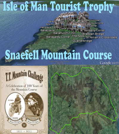
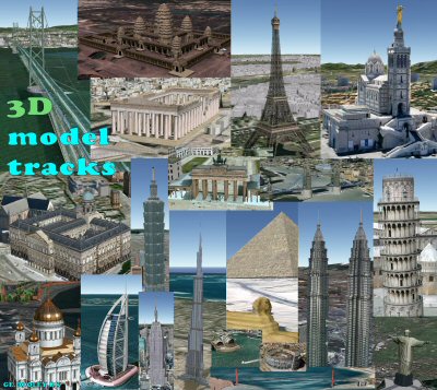
Dooley welcomes you Dooley welcomes you


dooley.dk/ge.htm
goo.gl/Uo46i
Google Earth GE.DOOLEY.DK

ge.dooley.dk

This site is about Google Earth and the files and information I've made, in relation to this great interactive connection to the surface of our earth called Google Earth. Although I've made all the files here, I do not own any of what references Google Earth, it's free for all of you.

If I own anything it may only be the design of context, the discovery and comments/descriptions of the placemarks, track/paths and overlay layouts in the kml/kmz files. My sole purpose was to make it. Just use it but I would appreciate a credit or source reference if you do. I did my best to make it useful, informational... And hopefully a bit interesting... :-) Enjoy, Tom Kjeldsen


Tom Kjeldsen
file lists at:


Google Earth Community Google Earth Community TK files - goo.gl/LA6pgN
Google Earth GE.DOOLEY.DK


Google Earth Hacks Google Earth Hacks TK files - goo.gl/rTTRX
Google Earth GE.DOOLEY.DK


Sites that host copies of (or links to) the files on this site and many other interesting GE files:

New Google Earth Community New Google Earth Community - goo.gl/XyQDpE
Google Earth GE.DOOLEY.DK


Google Earth Community Google Earth Community - goo.gl/y0w7h
Google Earth GE.DOOLEY.DK


Google Earth Hacks Google Earth Hacks - goo.gl/zWHMY
Google Earth GE.DOOLEY.DK


Earth links:

Download/Get the Google Earth program here at
earth.google.com
- goo.gl/9sW8o
Google Earth GE.DOOLEY.DK


Google Maps
maps.google.com
- goo.gl/4B0Lv
Google Earth GE.DOOLEY.DK

Latitude Longitude Finder

Google Earth GE.DOOLEY.DK Find the exact latitude and longitude of anyplace you wish! Drag, zoom and when you end up at you preferred designation click on that very spot on the map and a window will show the current latitude, longitude and zoomlevel. By default centeret at the original Royal Greenwich Observatory pinpointing the zero line of longitude (meridian).
try the GE Lat Long Finder here

Google Earth

Google Earth GE.DOOLEY.DK Welcome to this page about 'Google Earth'. Feel free to check out our homemade kmz files, google earth tours, placemark collections, presented random below, like; the Suez Canal tour, the Gudenaa and Skjernaa river tour, the Kiel Canal tour and the mighty Amazon river tour or the longest River Nile tour or the Yangtze river tour. Climb the highest mountains in the world in the Mount Everest tour and K1, K2, K3, K4, K5 mountains. Or take a tour through great and grand canyons along the Colorado river. Dive into the deepest part of the oceans by taking the Mariana trench tour or check out a lot of 3D models of buildings and structures in the 3D model tracks collection. Choose your next tennis game court in Denmark in the Tennis courts of Denmark or take a look at the Man in the moon :-). Follow one of the biggest mountain chains in the world; The Hawaiian-Emperor seamount chain or one of the most spectacular railway lines in the world; The Bergen Railway Line. Take a sailing trip on the Gota Canal or a ride on the Zambezi river to and beyond the Victoria Falls. See the scenic fiords and sounds of the New Zealand Fiordland area or the locks along the Volga Don Canal or the Panama Canal. You may also take a cruise into the sunset along the Californian Highway 1. Take a look at some of the longest brigdes in the world, over land and water, Danyang Kunshan Grand and Jiaozhou Bay Bridges. Relive the extreme hardships traveling into the unknown northern Greenland, back in the 19th century during The Danmark expedition. And several more files... Or let our Latitude Longitude Finder give you the coordinates of any place in the world! dooley.dk/ge.htm - goo.gl/Uo46i - ge.dooley.dk

bigger picture
Google Earth Tom exampel
Start/Download
tour here


Original published
30. Jan, 2014

Mississippi River tour

Google Earth GE.DOOLEY.DK The Mississippi River is the largest river in North America. "Mississippi" is a Ojibwa (Chippewa) Indian / Native Americans / First Nations word "misi-ziibi" or "gichi-ziibi" meaning great river, big river, gathering of water. The river is the major river of the eastern half of North America, flowing through the USA states of Minnesota, Wisconsin, Iowa, Illinois, Missouri, Kentucky, Tennessee, Arkansas, Mississippi and Louisiana. From the spring in it's northern Minnesota headwaters, it flow south for more than 2320 miles (3730 km) to the Mississippi River Delta at the Gulf of Mexico.

The river's original major silt deposits posed the Mississippi River Valley as a very fertile agricultural region, which contributed and resulted in the river's famous 19th century steamboat era. The decades following has seen the construction of massive engineering works such as levees, locks and dams, which has formed the river to it's present flow.

"New Orleans", on it's maiden voyage in 1811 from Pittsburgh to New Orleans, was the first steamboat on the Mississippi and Ohio River. Since then several steamboats were built over the next few years, including the "Comet" (1813), the "Vesuvius" (1814), the "Enterprize" (1814) and "Washington" (1817). Around 1817, with 12 steamboats on the western rivers, steamboat navigation where generally accepted, and within two years, there were over 60 steamboats on the western waters. In 1826 there were 143 steamboats on the river, and a total of 233 had existed up to that time. Around 1856, steamboats began to see competition from the railroads and declined. The steamboat era culminated in 1870 with the famous steamboat race from New Orleans to St. Louis between the Natchez VII steamboat and the Mississippi paddle steamer, the Robert E. Lee ("Monarch of the Mississippi"). Freight transportation on the Mississippi River saw huge growth via barge traffic through the 20'th century.

Location along the main channel of the river is denoted by river miles, starting with mile 0 at Head-of-Passes in the Mississippi River Delta and proceeding 953.8 river miles upstream to the mouth of the Ohio River (A track/path is supplied in this collection). Mileages are indicated as AHP (Above Head of Passes) or BHP (Below Head of Passes). Numbering of river miles starts again at 0 at the mouth of the Ohio River and continues up the Mississippi River to the spring at Lake Itasca.

About the "The Mississippi River tour": Take a tour along the entire Mississippi River with more than 900 placemarks between the spring and the estuary. Find most/all major bridges, dams, lakes, islands and river tributaries pinpointed along the Mississippi River. All divided and sub-divided into folders of the wide areas of the upper Mississippi, the central middle Mississippi and the lower Mississippi River. Tour creator: Tom Kjeldsen, created November 2013 to January 2014. Recommended to be viewed as a "Play tour" in Google Earth with 3D Buildings layer enabled.

The Google Earth TomKjeldsen File of all files..!

Tom Kjeldsen Google Earth Collection Network link file - This is the file of all files :-) the file that in the Google Earth program and application links directly to ALL (currently known) other site files (like GEC, GEH and GE.DOOLEY.DK and others)... thus this allow you to direct link and access all my files. Enjoy and all the best, Tom Kjeldsen.

Current post at the Google Earth Community

Original post at (the old retired) Google Earth Community

"""""""""""""""""""""""""""""""""
Quoted from original post as of 25/09-2011"; Here are the list of my humble contributions, so far, to this great Google Earth (GE) program and interaction. :-) Hope you enjoy this as much as I do - All the best, Tom Kjeldsen.

Well, I did not and do not really expect anyone to drop by this page, although I bid you so very welcome if/when/now you did/do. It was and is primarily meant as a shortcut for myself (and maybe you :-) ;-) ) to have easy access to and a chronological overview and list of the files I have made in Google Earth.

If you have any corrections, comments, additions feel free to comment in one of the forums on the internet. All files are also downloadable from ge.dooley.dk aka dooley.dk/ge.htm

"""""""""""""""""""""""""""""""""


The online list/post of files can be found at these great sites:
nGEC - new Google Earth Community
nGEC - Tom Kjeldsen files
oGEC - old Google Earth Community
oGEC - Tom Kjeldsen files
GEH - Google Earth Hacks
GEH - Tom Kjeldsen files

Take your pick, there are so many places to see. In total all our combined files, for now, gives you more than 31 continuous hours of flying over and to places on earth and above. Feel free to download our files, one at a time. You can also choose to load the current entire 'collection of collections' to give direct access to all tours and files. Download the attached "Current-Complete-Google-Earth-Collection-Of-All-Collections-And-Files-Made-By-Tom-Kjeldsen-network-links" and click to load and enable the tour file of you choise. Please be aware that this could pose some challenges to (your?!) computer performance due to the fact that the file (if all enabled) consist of several graphic overlays, 10'th of thousands of points in path/tracks and at least 7000 placemarks, last time we took a count. We could recommend you to play / download the tours / files / collections one at a time... BTW, to see how posts looked like back around and upto 2011 see this pdf (dooley.dk/GoogleEarthPosts-by-TomKjeldsen-2011-09-18-GEC.pdf) - And to see how posts looked like back around and upto 2015 see this pdf (http://dooley.dk/GoogleEarthPosts-by-TomKjeldsen-2015-04-28-GEC.pdf)

Have a nice google earth tour... Let's explore! :-)
bigger picture
Google Earth Tom exampel
Start/Download
tour here


Original published
28. March, 2008

Mount Everest tour

Google Earth GE.DOOLEY.DK Mount Everest. The World's highest mountain, tallest peak. Also called Sagarmatha (Nepal, meaning "Head of the Sky"), Chomolungma (Tibet, meaning "Goddess Mother of the World"), Qomolangma (China), Zhumulangma (Pinyin) and originally named peak XV, peak 15 when it was discovered and classified. Mount Everest is a part of the Himalaya range in High Asia, located on the border between Sagarmatha zone of Nepal and Tibet. The mountain was first observed and recorded from great distance as "peak b" in november 1847. In 1856, the Great Trigonometric Survey of India established, after several years of calculations, the first published height of Everest at 29002ft (8840m). The most current official height is 8848m (29029ft), first determined by an Indian survey in 1955, and subsequently reaffirmed by a 1975 Chinese measurement. Because of the still active geological forces Mount Everest rises by approx. 1 centimeter (0.4 Inch) per year, and move simultaneously towards the northeast at a speed of 6 centimeter (2.4 Inch) per year. Asked "Why do you want to climb Mt. Everest?" George Mallory is famously quoted as having replied "Because it is there!". During the British 1924 Mount Everest Expedition Mallory and his climbing partner Andrew Irvine both disappeared somewhere high on the North-East ridge during their climb. The New Zealander Edmund Hillary, and the Nepalese Sherpa Tenzing Norgay, was the first to reach the summit of Mount Everest at 11:30 local time the 29th of may 1953 after a climb up the southern face. The mountain, while not posing substantial technical climbing difficulty on the standard routes still has many inherent dangers such as altitude sickness, weather and wind. The highest mountain in the world attracts climbers of all levels. By the end of the 2007 climbing season, there had been 3679 ascents to the summit by 2436 individuals and Everest has claimed 210 lives. In average 2 to 4 fatal casualties every year since the start of the mountains exploration.

About the "Mount Everest tour": This is a series of placemarks and tracks that will give an impression of the climbing tour from basecamp(s) to the top of the world. The 2 major routes (out of at least 18 routes) are (roughly) shown in red (North Col, Northeast ridge) and blue (South Col, Southeast ridge). Camp positions are primary based on locations during the first ascents more than 50 years ago. Up till today both strength of climbers and climbing gear has developed so that a few camp locations may be obsolete at present time. Several places of mountain climbing interest along the two routes are also pinpointed. The tour is divided into 5 main folders; "The Summit (Around the Everest top)", "Southern area including Southeast ridge (South Col) route", "Northern area including Northeast ridge (North Col) route", "Eastern area" and "Peak Pictures - Mount Everest". Additional folders are "Map, Route, Zone Overlays", "Geological Overlays", "Track4Play", "How to get to basecamps on Mount Everest..." and "Historic imagery links" gives various opportunities to explore the area around the highest mountain on earth supplied with on/off clickable grids, maps and images. The 'Play tour' option of GE will take you on a trip on first the south, then the north and then the east approach. Finally we take a flight around the summit. And end up in displaying a series of old and new pictures from around Mount Everest. Also available are 4 tracks, "track4play" each one designed to take you from the south, north, east or west areas, to or very near the top. Just 'play the track' and let GE do the climb! Consider using a viewing angle of 80 degrees or above. To ajust viewing angle, choose menu 'Tools', 'Options', Click the tab 'Touring' and change the 'Camera Tilt Angle' to 80 degrees. The default is 45-60 (below 80) degrees. Please note that all tracks are very much approximations of the plausible route and nothing near the exact climb. No one has been hurt during the use of this for climbing (mostly because no one hopefully has used them), but they will, if they do!!! The 'South Col' tour is considered the 'easy' trip, but I believe that people taking (the real) tour to the top of Everest are really tough people, no matter what route they take! Even from satellite pictures and Google Earth terrain feature you get a feeling (and I guess never near the real thing) of how really really big this mountain is! Tour creator: Tom Kjeldsen, created march 2008. Recommended to be viewed as a 'Play tour' in Google Earth with terrain feature enabled.
bigger picture
Google Earth Tom exampel
Start/Download
tour here


Original published
12. Dec, 2016

The shortest scheduled flight in the world

Google Earth GE.DOOLEY.DK The Loganair Westray to Papa Westray route is the shortest scheduled passenger flight in the world. Flights on this route are scheduled for two minutes, and actual flying time is closer to one minute. The record for the fastest flight is 53 seconds. The route is flown by Loganair, a Scottish regional airline. Started in 1967 the flight in November 2016 had it's one million passenger count.

Included in this tour collection is detailed as possible path/track to show the flight route. Also, partly based on path/track and done by 'manual navigation input' is, a pre-recorded autoplay tour.

Tour creator: Tom Kjeldsen, created december 2016. Recommended to be viewed as a 'Play tour' in Google Earth with terrain and 3D etc. layer enabled. If you have any corrections, comments, additions feel free to comment in one of the forums on the internet.

Take a real world window view tour of the flight onscreen via this youtube video: https://www.youtube.com/watch?v=fwyVWaCAD2A
bigger picture
Google Earth Tom exampel
Start/Download
tour here


Original published
27. Oct, 2015

Isle of Man Tourist Trophy Snaefell Mountain Course

Google Earth GE.DOOLEY.DK The Snaefell Mountain Course is a road-racing street circuit used for the Isle of Man motorcycle TT race since 1911. The track course include a staggering 37.73 miles (60.72 km) long road race lane with the start and finish line at the TT Grandstand situated on the A2 Glencrutchery Road in the town of Douglas. The path is used for high speed racing in various motorcycle categories during the annual Isle of Man TT festival at the end of May and beginning of June. The more than hundred year old race has for years been seen as one of the most prestigious and oldest motorcycle races in the world and is regarded as one of, if not the most dangerous motorcycle road-race in the world.

The yearly main event is the Senior Tourist Trophy (Senior TT) race, which currently include completing 6 consecutive laps.

"The current lap record for the Senior TT class is 17 Minutes and 3.6 seconds at an average speed of 132.7 mi/hr (213.5 km/hr) set by John McGuinness during the 2015 Senior TT Race. The race record for the Senior TT is 1 hour, 45 minutes and 20.394 seconds, at an average race speed of 128.943 mi/hr (207.5 km/hr) set by John McGuinness in 2013 during the 6 lap (236.4 Miles / 380.3 Kilometers) race. The longest race distance for a FIM Motorcycle Grand Prix World Championship event was the 500cc 1957 Isle of Man TT race. The 8 lap (302.0 Miles / 485.9 Kilometers) 1957 Senior TT race was won by Bob McIntyre riding a 500cc Gilera in 3 hours, 2 minutes and 57.0 seconds at an average race speed of 98.9 mi/hr (159.3 km/hr)."

It does not only have to be good skilled motorcycle drivers to ride a 236 miles / 380 kilometer tour in 1 hour and 45 minutes. When they furthermore do it on this track with hundreds of corners and elevations over a very long lap distance in ultra high speed, it's just impressive that anyone even dare to do this. Enjoy that someone are skilled enough to do this, but don't do this at home :-)

About this "Isle of Man Tourist Trophy Snaefell Mountain Course": Take a motorcycle ride on a 38 miles / 61 kilometer long track and see all major named corners on the track. Tour creator: Tom Kjeldsen, created october 2015. Recommended to be viewed as a 'Play tour' in Google Earth with terrain feature enabled.
bigger picture
Google Earth Tom exampel
Start/Download
tour here


Original published
21. Apr, 2013

Jungfrau Railway Train Tour

Google Earth GE.DOOLEY.DK The Jungfrau railway is an 9 kilometres cog, toothed railway of which the top 7 kilometres is inside a mountain tunnel. The railway climbs almost 1400 altitude meters (4600 ft). The railway inside the Eiger and Mönch mountain massive include 2 active stations, the "Eigerwand railway station" inside Eiger mountain, which offer an impressive view from and of the 1800 m (5900 ft) Eigerwand ("Eiger North wall") and the "Eismeer railway station" on the col between Eiger and Mönch with a spectacular view of the Eismeer ("Icesea") Grindelwald-Fiescher glacier. The railway ends below the Sphinx Observatory at the Jungfraujoch ("Jungfrau col") railway station, the highest railway station in Europe at 3454 m (11333 ft)

About the "Jungfrau Railway Train Tour": The tunnel (red) track/path is not precise, mostly an outline, due to no found official altitude and position data avaiable. Station positions along track/path should be fairly close to real world. Recommended to be viewed as a 'Play tour' in Google Earth with the '3D buildings' and terrain layer enabled and a viewing angle above 80 degrees for touring track/path. To adjust viewing angle, choose menu 'Tools', 'Options', Click the tab 'Touring' and change the 'Camera Tilt Angle' to above 80 degrees. The default is 60 degrees. To play a specific path track, mark the 'three dot icon' path track, press the 'Play tour' option and enjoy the train ride. Tour and track creator: Tom Kjeldsen, created april 2013.
bigger picture
Google Earth Tom exampel
Start/Download
tour here


Original published
12. December, 2012

The Thor Heyerdahl Sailing expeditions

Google Earth GE.DOOLEY.DK Colonisation of the new worlds! In 1938 and ahead Norwegian Thor Heyerdahl proved by a series of sailing trips in rafts of ancient design that it was possible for Americans to reach Polynesia (The Kon Tiki expedition), that Africans/Europeans could reach the Caribian and further on to the Americas (The Ra expeditions) and that the world's earliest urban civilizations, like the Mesopotamia at the Persian Gulf to the, now Pakistan, ancient Indus Valley Civilization, further on to Egypt (The Tigris expedition). Although discussed among anthropologists whether this happened, Heyerdahl basically proved it was possible to travel the vast distances in boats designed as they were build in these ages.

The Kon-Tiki expedition. Balsa tree raft. On a 101 days, 4300 nautical mile (4948 miles, 7964 km) journey from Callao, Peru, starts on April 28, 1947. Sailing west across the Pacific Ocean carried along on the Humboldt current at a speed of average 1.5 knots. First sight of land is Puka-Puka atoll on July 30. On August 7 Kon-Tiki hits into the reef at Raroia in the Tuamotu Islands. The crew survives the dramatic landing on the uninhabited Raroia island and are rescued by locals after a few days.

The Ra I and Ra II expeditions. Papyrus reed rafts. Both expeditions starts from Safi, Morocco and travels west across the Atlantic Ocean towards Barbados in the Caribbean. Ra I sets off May 25th 1969. After 54 days and 2662 nautical miles, on July 18th 1969, about 700 nautical miles from Barbados, parts of the Ra I raft starts to fall apart, and the expedition has to abandon ship, as the raft is sinking. Ra II sets of on May 17th 1970 and reaches Barbados on July 12th 1970 after 3270 nautical miles in 57 days.

The Tigris expedition. Berdi reed raft. The Expedition starts out on the Tigris River in december 1977 and lasts for 5 months and more than 3400 nautical miles. In protest of having being surrounded by wars on every side in the Red Sea and Horn of Africa, the expedition decides in april 1978 outside Djibouti to set fire to the raft, and in an open letter make an appeal to UN to do an effort to stop the arms deliveries to developing counties in the region. The purpose of the expedition still proved it possible to sail and navigate from ancient Mesopotamia to the 'new' world around red sea ancient Egypt.
bigger picture
Google Earth Tom exampel
Start/Download
tour here


Original published
7. July, 2012

Congo River tour

Google Earth GE.DOOLEY.DK The Congo River. The worlds deepest river, with measured depths beyond 230 meters / 750 feets. So deep and fast flowing, that fish species from one river bank is unable to cross the river, making unique species living and evolving on each side of the river banks in specific areas of the river.

After the Congo River estuary to the Atlantic Ocean the river water produces so much force that the Congo Submarine Canyon is formed. The worlds largest underwater river canyon, extending from the Congo River estuary, more than 800 kilometers / 497 miles from shore, and deeper than 1200 meters (3900 feets) below sea level.

Flowing through the worlds second largest rainforest the 4700 km / 2920 mi long Congo River (former known as Zaire River) is the second largest in the world in terms of water discharge.

The Boyoma Falls (Stanley Falls) and Inga Falls, the most powerful part of Livingstone Falls on the lower course of the Congo river, produces the most powerful and voluminous river waterfalls and cataracts in the world.

The source of the Congo River is the Chambeshi River spring in Zambia, forming the Kasama swamps and floodplain and from Lake Bangweulu flowing into Luapula River, to Lake Mweru, and then into the Luvua River. The other major source is the Lualaba River which originates in most southern part of Congo. The Lualaba River joins the Chambeshi River at the city of Ankoro forming the upper Congo River. The Lukuga River originating from Lake Tanganyika joins the Congo River at Ilunga forming the remaining upper Congo River down to and through the Boyoma Falls (Stanley Falls).

The Congo River at Kisangani marks the start of the Congo River, below it's upper sources, with all of it's tributaries. Flowing through vast rainforests and wetlands, the river ends up in the Malebo Pool at the two Congo capitals Kinshasa and Brazzaville, starting a rush downwards through the longest waterfall in the world, the 220 mile / 350 km long Livingstone Falls, including Inga and Yellala Falls.

About the "The Congo River tour": Take a tour along the entire Congo River with more than 450 placemarks between the various spring rivers and the estuary. Tour creator: Tom Kjeldsen, initial idea December 2011, created January to July 2012. Recommended to be viewed as a 'Play tour' in Google Earth with terrain feature enabled.
bigger picture
Google Earth Tom exampel
Start/Download
tour here


Original published
12. May, 2008

Colorado River tour

Google Earth GE.DOOLEY.DKThe Colorado River, 'Aha Kwahwat in Mojave, Río Colorado (Red River) in Spanish, is a river in the southwestern United States and northwestern Mexico, approximately 1450 miles, 2333 kilometers long, draining a part of the western slope of the Rocky Mountains. The river course take you from the source in the impressive snow-covered mountain landscapes, over dams and lakes, through deep eroded canyons and dry desert areas to the estuary in the Gulf of California.

The existence of the Colorado River was first discovered and noted in the records of written history in September 1539, when Francisco de Ulloa sailed to the head of the Gulf of California and rowed a short distance upstream.

The Colorado River spring is La Poudre Pass Lake, located high in Rocky Mountain National Park, just west of the Continental Divide. "Grand River" is the name once applied to the Colorado River from its headwaters in Rocky Mountain National Park to its confluence with the Green River. This gave rise to several names including Grand Lake, Grand Valley and Grand Junction. The earliest appearance of this name on a map could be on the map by Henry Schenck Tanner from 1836. The name there replaces the name of Rio Rafael, which appears on many earlier maps. In 1921 Grand River was officially renamed to Colorado River.

The Colorado River continues from the Rocky Mountains down into the upper canyon areas of Colorado and Utah, along with several tributaries and reservoirs. Then the river enters Arizona and the Glen Canyon area with countless canyons, mountains and bays. Downstream of the Glen Canyon Dam the river passes the Navajo Bridge and enters the Grand Canyon area, with some of deepest canyons and most impressive rock formations. At the Grand Canyon end, it exit out into Lake Mead, in Nevada, with its numerous bassins and coves. Below the mighty Hoover Dam the Colorado River run into the Desert area which is shared with Arizona and California and includes several dams. Finally the Colorado River cross the border from USA into Mexico and ends up at the river estuary at the Gulf of Mexico.

About the "Colorado River tour": Take a tour along the entire North American Colorado River from the spring in the Rocky Mountain lake 3101 meters, 10174 feets above sealevel, through hundreds of canyons including Grand Canyon, crossing dams and lakes like the Hoover Dam and Lake Mead and finally flowing into the Gulf of California. More than 1000 placemarks, in average one every 1.5 mile, 2,5 kilometers, guide you along the river. At the end of the placemark collection of folders the 'overlays' folder offer various displays like national parks, the watershed, the river states and the river basin. Check out detailed track/path of the river source area from the spring at La Poudre Pass Lake, including the Grand Ditch, down to Shadow Mountain Lake. Also the entire Grand Canyon River from the start at Lee's Ferry in Glen Canyon to Pearce Ferry at Grand Canyon end, all 279 Miles is mapped detailed as track/path. Location of all named rapids in the Grand Canyon are placemarked. Also various notable whitewater rapids in canyons like Gore Canyon and Westwater Canyon are pinpointed. In lower Colorado River area detailed track/path outline All-American Canal and the Mexican Morelos Canal. Tour creator: Tom Kjeldsen, created may 2008. Recommended to be viewed as a 'Play tour' in Google Earth with terrain feature enabled.
bigger picture
Google Earth Tom exampel
Start/Download
tour here


Original published
30. June, 2013

Fairy Circles of the Namib Desert

Google Earth GE.DOOLEY.DK Fairy circles are small circles in the Namib desert, mostly seen in a belt, a climatic band where it rains between 5-10 centimeters per year, about 150 kilometers from coastline from northern to southern Namibia. They are typically 2-12 meters in diameters and have a lifespan of 30-60 years.

Namibia's native, called Himba, call the circles "footprints of god". When their god Mukuru rarely let the rain fall upon the very dry desert, he leaves his footprints in the sand. And they will never disappear, according to Himba. Other people in the area believe it is underground dragons spewing toxic gas from small fissures in the ground, and more recently also started talking about aliens and UFOs...

None of these explanations can hardly stand a more objective investigation. Scientific studies has been ongoing since 1971 and over the years many of the theories has been just as interestingly strange as the ancient old explanations. Fairy circles has been thought to come from; himba tribal dance, meteorites, radioactivity, dizzy ants or dying branches from the cactus 'live stick'.

Several biologists has since 1994 stuck to termites being the creators of the circles. The reason, why and how, has caused additional explanations, like that termites might fart toxic gases that make the grass die. In 2012 radar recordings showed a moist layer of soil 10 feet below the surface, directly below the circles.

Latest termite hypothesis states that the sand-termit "Silvestri (Psammotermes allocerus)" is using the circle as a water reservoir. It eats the roots from below, making sand bare and extremely porous. When it rains on rare occasions, the water sinks quickly down through the sand, rather than evaporate, and since there not are any plants, it will not transpire through them. Fairy circles are in other words, artificial ponds, which termites build and maintain for decades.

The circle shape is a result of the natural breakdown in the underground, where it nourishes the surrounding grassland outside the rainy season.

During periods of prolonged rain, termites stop eating roots and fairy circles will be covered with grass, because there is no longer any need for ponds. In areas where it rains less than 5 cm per year, the fairy circles in turn not viable, probably because there is not enough water to sustain wildlife habitat around the circles.

The toxic gases measured in and around the circles is also due to termites. The termite stomach contains, as in cows and humans, bacteria that help break down the plants. Although the termite Silvestri, like other termites, prefer death cellulose, it has specialized in chewing living plant roots to maintain the ponds. This provides gas and constipation in the stomach, which may be out by natural means. - Tour and track creator: Tom Kjeldsen, created january-june 2013.
bigger picture
Google Earth Tom exampel
Start/Download
tour here


Original published
5. May, 2012

The Vitus Bering expeditions

Google Earth GE.DOOLEY.DK Vitus Bering was a Danish born Russian captain and commander who from 1725-1730 and 1733-1742 leads 2 expeditions from Saint Petersburg across the entire Russian country to investigate the extent of the Russian empire for the Tsar Peter the Great and to determine whether Asia/Russia and North America are connected by land. The 2 expeditions ends up at travelling a basic distance of at least 67800 kilometers / 42130 miles, more than one and a half around the earth. This without including numerous additional supporting exploration tours.

The first expedition leaves Saint Petersburg in 1725 and reaches Okhotsk 3 years later. Two ships "Vostok" and "Fortuna" are build and the Okhotsk sea is crossed to Bolsheretsk on eastern side of the Kamchatka peninsula. The peninsula is crossed along the Kamchatka River where a new settlement, the present Ust-Kamchatsk, is founded. A new ship is being build in 1728 and on the 13th of July the sixty feet long ship "Sankt Gabriel" sails out on the Bering sea along the Russian coast. In August the expedition reaches the northern latitude of 67° 18', thus discovering the Bering Strait and the Diomede islands. Due to heavy fog the expedition fails to get sight of the low-lying shore of Alaska and North-America.

Back in Saint Petersburg in 1730 Vitus Bering plans an even larger second expedition which take off in February 1733 with 600 men and arrive 7 years later in 1740 to Okhotsk after a land and sailing journey across the entire Russia of more than 6200 miles / 10000 kilometers. Three ships are build and launced into the Okhotsk sea. Only 2 reaches the Avacha Bay in south-eastern Kamchatka, on October 6th where the port of Petropavlovsk is established.

The 2 ships, Bering on the "St. Peter" and captain Chirikov on the "St. Paul", are departing Petropavlovsk on a South-East course on June 4th 1741. On June 20th, the 2 ships become separated in dense fog and stormy weather and continue their exploration separately.

The "St. Paul" is headed on more southern course and discover Baker island on 15th of july 1741. Other islands like Prince of Wales and Baranof Islands are discovered until lack of water and missing options for making landings forces captain Chirikov to set course back towards Petropavlovsk which "St. Paul" reaches only few days before water supply runs dry.

"St. Peter" makes sight of Mt. St. Elias and Alaska on 16th of july 1741, and 3 days later Saint Elias (now Kayak) island is discovered, named and landing is made. In spite of storms between Aug. 10th and Sept. 6th and severe starvation several islands are discovered like Kodiak and Shumagin.

While heading back towards Kamchatka the expedition is hit by violent storms from Sept. 26th to Oct. 16th. Struggling their way along the Aleutian Islands the "St. Peter" with Vitus Bering lands and become shipwrecked at Bering island in late autumn of 1741 on November 6th. On December 8th Vitus Bering dies on the Island. In April 1742 the surviving 46 of the 77 crew members on "St. Peter" manage to build a vessel and in August cross over to Kamchatka, successfully reaching Avacha Bay.

About "The Vitus Bering expeditions" tour: All tracks and paths are approximations to the actual routes both due to the very vast areas covered and the lack of precise data in addition to almost countless additional sled rides, over land travels, river and sea explorations and preparations for the basic expedition. Tour creator: Tom Kjeldsen, created May 2012.
bigger picture
Google Earth Tom exampel
Start/Download
tour here


Original published
29. Sep, 2014

Whistler Sea to Sky Climb with Rocky Mountaineer

Google Earth GE.DOOLEY.DK Whistler Sea to Sky Climb with Rocky Mountaineer is a railroad track from Northern Vancouver to Whistler and back. It features impressive mountain, river and waterfall views and sightings. It has several times been regarded as one of the worlds most spectacular train rides.

Included in this tour collection is detailed path/tracks, to and from, on ground and 50 meters (164 feet) above ground. Also, partly based on path/track is, 3 pre-recorded autoplay tours;

- Vancouver to Whistler Sea to Sky Climb
50 m above ground route autoplay

- Whistler to Vancouver Sea to Sky Climb
50 m above ground route autoplay

- Vancouver to Whistler Sea to Sky Climb
flyover autoplay

Tour creator: Tom Kjeldsen, created september 2014. Recommended to be viewed as a 'Play tour' in Google Earth with terrain and 3D Buildings layer enabled.
bigger picture
Google Earth Tom exampel
Start/Download
tour here


Original published
29. April, 2012

Si Du River Bridge, world highest above ground

Google Earth GE.DOOLEY.DK Si Du River Bridge, world highest above ground. The suspension bridge is 1.627 feets / 496 meters high above ground and spans 2.952 feets / 900 meters. The brigde was opened at the 15th of november 2009 and is located in Badong area of Hubei, China. Due to the extreme depth of the canyon below the projected brigde a new technique was used to mount the initial suspension cable. A rocket was fired from one side attached with cable and landed on the other side making it possible to tie the first connection between the anchoring pills of the brigde.
bigger picture
Google Earth Tom exampel
Start/Download
tour here


Original published
3. July, 2011

Danyang Kunshan Grand Bridge, the worlds longest

Google Earth GE.DOOLEY.DK The Danyang Kunshan Grand Bridge is the worlds longest brigde. It is 164,8 kilometers, 102,4 miles, 540709 feet, 164800 meters long. It was completed in 2010 after four years of construction and opened on June 30, 2011.

The brigde is part of the 1318 kilometers (819 miles) long Jinghu high-speed railway also known as the Beijing-Shanghai high-speed railway.

About the "Danyang Kunshan Grand Bridge tour": See the start and end of the very long brigde, including current and historic placemarks along the brigde. Included is detailed tracks composed from various sources to show the current most precise path of the entire bridge, included a pre and post path at the start and end of the brigde. The tracks/path are at 33m/99ft level above ground to let you do a play track with a view from a bit above ground. Consider adjusting the GE 'Camera tilt angle' to 80 degrees or above, in 'tools, options..., touring', for better display when playing tracks/paths. Enjoy! Tour creator: Tom Kjeldsen, created july 2011. Recommended to be viewed as a 'Play tour' in Google Earth with terrain feature enabled.
bigger picture
Google Earth Tom exampel
Start/Download
tour here


Original published
9. September, 2011

Ned Kelly, The Irish Australian bushranger

Google Earth GE.DOOLEY.DK Edward "Ned" Kelly, born between June 1854-55, hanged the 11th of November 1880, was an Irish Australian bushranger. He is considered by some to be a cold-blooded killer, by others to be a folk hero and symbol of Irish Australian resistance against oppression by the British ruling class and for his defiance of the colonial authorities in 19th century Australia. A child of a Irish father and a Australian farmers daughter he was born between June 1854 and June 1855 in Beveridge. 14 year old he was first arrested for assault, and at the age of 16 sentenced to three years imprisonment with hard labour for "feloniously receiving a horse". In 1878 Ned Kelly and his brother Dan went into hiding, where they later were joined by their friends Joe Byrne and Steve Hart and formed the Ned Kelly Gang.

On 25 October 1878 police officers set off to search for the Kellys and set up a camp at Stringybark Creek. A second police party set off from Greta near the Wangaratta end, with the intention of closing in on Ned in a pincer movement. At the end 3 of the 4 policemen were killed during gunfire, and as a response to these killings the Victorian parliament passed the Felons' Apprehension Act which outlawed the gang and made it possible for anyone to shoot them. Following the killings at Stringybark, the gang committed two major robberies, at Euroa at 10 December 1878 and Jerilderie on Saturday 8 February 1879 which both involved the taking of hostages and robbing the bank safes.

Months prior to arriving in Jerilderie, and with help from Joe Byrne, Ned Kelly dictated a lengthy letter for publication describing his view of his activities and the treatment of his family and, more generally, the treatment of Irish Catholics by the police and the English and Irish Protestant squatters. The Jerilderie Letter, as it is called, is a document of 7,391 words and has become a famous piece of Australian literature.

The Kelly Gang arrived in Glenrowan on 27 June and took about 70 hostages at the Glenrowan Inn, wearing armour tough enough to repel bullets. The Kelly gang's attempt to derail the police train, they knew was comming, failed. Firearm shooting was started at dawn on Monday 28 June. The Kelly Gang members where shot and died in the hotel. At the end Ned Kelly was shot repeatedly in the legs and as he fell he was hit by a shotgun blast that injured his hip and right hand. Ned Kelly survived to stand trial, and was sentenced to death. When the judge uttered the customary words "May God have mercy on your soul", Kelly replied "I will go a little further than that, and say I will see you there when I go". At Ned's request, his photographic portrait was taken and he was granted farewell interviews with family members. His mother's last words to Ned were reported to be "Mind you die like a Kelly". He was hanged on 11 November 1880 at the Melbourne Gaol.

In August 2011, scientists publically confirmed a skeleton exhumed from the old Pentridge Prison's graveyard was that of Ned Kelly, after comparing the DNA to that of Kelly's great grand nephew.

Tracks, Path are supplied to help to assist the chronology of the placemarks. Descriptions, stories and information on the individual placemarks are mainly excerpts from the great compelling and comprehensive article http://en.wikipedia.org/wiki/Ned_Kelly on wikipedia. Tour creator: Tom Kjeldsen, created September 2011.
bigger picture
Google Earth Tom exampel
Start/Download
tour here


Original published
28. July, 2011

The Jacobite Steam Train Railway Track tour

Google Earth GE.DOOLEY.DK The Jacobite Steam Train Railway Track, "The Railway to the Isles", is described as one of the great railway journeys of the world. This 41.3 miles (66,5 kilometers) long track takes you past a list of impressive sites. Starting in Fort William near the highest mountain in Britain, Ben Nevis, it visits Britain's most westerly mainland railway station, Arisaig; passes close by the deepest freshwater loch in Britain, Loch Morar and the shortest river in Britain, River Morar, finally arriving at Mallaig next to the deepest seawater loch in Europe, Loch Nevis.

The train crosses the 21-arched Glenfinnan viaduct, a location made famous when travelling with the Hogwarts Express in several Harry Potter films. The train stops on the route to Mallaig at the village of Glenfinnan which overlooks Loch Shiel and The Glenfinnan Monument, The Jacobite. Next stop is Arisaig. From here, on a clear summer's day, you can see the "Small Isles" of Rum, Eigg, Muck, Canna and the southern tip of Skye. The train continues on from here passing Morar and the silvery beaches used in the films "Highlander" and "Local Hero".

Tour creator: Tom Kjeldsen, created july 2011. Path of the track is avaiable, one at ground level showing the railway direction, a second above level suitable for playing the path. Recommended to be viewed as a 'Play tour' in Google Earth with terrain feature and '3D buildings' layer enabled.
bigger picture
Google Earth Tom exampel
Start/Download
tour here


Original published
28. July, 2011

Caledonian Canal tour

Google Earth GE.DOOLEY.DK The Caledonian Canal, connecting Inverness to Fort William in Scotland, is 59 miles (94 kilometres) long. 22 miles (35 kilometres) are man-made to connect the natural lochs, of Loch Lochy, Loch Oich, Loch Ness and Loch Dochfour. The canal was opened in 1822. It was constructed to help commercial shipping avoid the treacherous journey around the Scottish west coast.

The Canal follows the Great Glen (Glen Albyn) fault across northern Scotland from the Moray Firth and Inverness at the North Sea in the north east to Loch Linnhe and Fort William at the North Atlantic Ocean in the south west. There are 29 locks, four aqueducts and 10 bridges in the course of the canal.

The building of the canal was planned in 1803 by the canal engineers Thomas Telford and William Jessop. Expected to take seven years to complete, the canal finally opened in 1822, having taken an extra 12 years to complete due to several problems and the difficulties of the construction of the locks, the largest ever built at the time. The Swedish Gota Canal is a sister canal of the Caledonian Canal also constructed by Thomas Telford from 1810-1832 using the most advanced expertise and equipment in the world at that time.

About the "Caledonian Canal-tour": Take a tour over this canal crossing the Scottish highland connecting the famous lakes, lochs. Also included are 2 paths following the entire canal, one at ground level showing the canal direction, a second above level suitable for playing the path. Recommended to be viewed as a 'Play tour' in Google Earth with terrain feature and '3D buildings' layer enabled. Tour creator: Tom Kjeldsen, created july 2011.
bigger picture
Google Earth Tom exampel
Start/Download
tour here


Original published
30. June, 2011

Jiaozhou Bay Bridge, worlds longest over water

Google Earth GE.DOOLEY.DK The Jiaozhou Bay Bridge, the Qingdao Haiwan Bridge is the worlds longest brigde over water. It is 42,5 kilometres, 26.4 miles long and was opened on June 30, 2011.

The bridge connects the city of Qingdao in the east/south with Jiaozhou in north/west and the Huangdao in the south/west across the waters of the northern part of Jiaozhou Bay. Tour creator: Tom Kjeldsen, created june 2011.
bigger picture
Google Earth Tom exampel
Start/Download
tour here


Original published
27. April, 2011

The Danmark expedition

Google Earth GE.DOOLEY.DK The Danmark (Denmark) ekspedition named after the expedition ship "Danmark" is a Danish led expedition to Northeast Greenland in the years 1906-1908. The purpose of the expedition is to explore and map the northernmost East Greenland. Since the 1700s, Greenland has been slowly mapped piece by piece, but the harsh climate of the northeast region has meant that no one had managed to get far north up the Greenland eastcoast. At least 1600 kilometers (1000 miles) of coastline are unknown yet waiting to be discovered and mapped from Kap Bismarck up to the northern region near Cape (Kap) Bridgman. The plan of the expedition is to sail with the expedition ship as far north as possible, establish a base and then travel by dogsled further north along the coast, mapping the geography.

The expedition leader Ludvig Mylius-Erichsen plan extensive studies and travel using dog sleds, and the result is a total of more than 6500 km (4039 mi) travel on dog sled, a record distance on Arctic expeditions. The 2 major single sledge journeys, Team 2 with Koch as leader, ends up being about 2000 km (1243 mi) long, and Team 1 with Mylius-Erichsen as leader, may have exceeded 1800 km (1118 mi).

On an expedition in 1900 the American Robert Peary claims that a east-west channel separate the enourmous mainland of Greenland from the northern-most north-east part, named Peary Land. One of 2 primary goals of the Danmark expedition is to investigate whether this is true or false. The second goal is to find Peary's cairn raised at Wyckhoff Land, the most eastern point reached on the Peary expedition.

Although the main objective for the expedition is to map the last unknown coastal areas of Greenland, very diverse research is being conducted and numerous scientific results being collected during the expedition, including the German scientist Alfred Wegener's discovery that the earth surface moves, which a few years later led to his theory of plate tectonics.

In June 1906 the expedition ship "Danmark" departs from Copenhagen. After crossing the North Atlantic sea for a month the expedition arrives to East Greenland in August 1906. The expedition base Danmarkshavn is being designated and established and during the autumn and winter multiple preparations is made to support the dogsled journey the following spring up north along the unexplored northern eastcoast. In March 1907 four Teams, 10 men, 10 sleds and approx. 80 dogs starts out of Danmarkshavn. In April 1907 the most eastern part of Greenland, Nordostrundningen is discovered. Team 3 and 4 has already headed back towards the base. Shortly after passing Nordostrundningen the remaining 2 teams splits up; Team 1, Mylius-Erichsen, Niels Peter Hřgh Hagen, Jřrgen Brřnlund, who will search and verify if the Peary channel exist, and Team 2, Johan Peter Koch, Aage Bertelsen, Tobias Gabrielsen, to identify the East Coast up to Peary's cairn. With very little or nothing to hunt all men and dogs are starving. In May 1907 Team 1 discovers an approx. 200 km. deep fjord, which they believe is Independence Fjord. When they realize their mistake they name it Danmark Fjord and turn back out of the fjord. Meanwhile, Team 2 has, after a tough and grueling dogsled journey across the sea ice, reached Peary Land, located Peary's cairn and traveled further as long as up to Cape Bridgman. On 28 May Sled Team 1 and 2 meets by an almost unbelievable coincidence in time, Team 1, on their way back out of Danmark fjord, and Team 2, on their way back from Cape Bridgman. This meeting place is named Kap Rigsdagen. Both teams decide to hurry back to the base in Danmarkshavn (Denmark Harbour) 750 km to the south. But the next morning Mylius-Erichsen has changed his mind. He announces that he and his team will spend a few days exploring Independence Fjord and then return. Therefore the two teams separates again. Team 1 heads for Independence Fjord - Team 2 heads back to base. On 23 June sled Team 2 arrives back to Danmarkshavn. Meanwhile, Team 1 has mapped the Independence Fjord. A few days have become weeks and the Greenland summer makes it continually harder and harder to travel with dog sleds. After a hard and risky trip back out of Independence Fjord, they finally reach Danmark Fjord in August 1907, where they are forced to camp until frost again makes it possible to travel. Worn out footwear and lack of materials makes it difficult and painful to hunt game. In order to survive sled dogs, one after one, must act as a small but yet a meal. This is an extremely difficult decision, both because of the close relationship between dogs and sled driver, but also because the reduction in the dog team inevitably mean that it will be, if possible, even harder to get back to the base in Danmarkshavn. In September 1907 Team 1 breaks up from the summer camp and, and in October 1907, from the bottom of Danmark Fjord they fight their way for 4 days to climb the Greenland ice sheet with only five remaining dogs. For almost a month they fight their way across the ice sheet. In November 1907 they reach Nioghalvfjerdsfjorden (79° Fjord). Without food and supplies and unable to reach a depot, first Niels Peter Hřgh-Hagen dies, then Ludvig Mylius-Erichsen days later. Jřrgen Brřnlund succeeds in reaching the depot at Lambert Land and then to find a cave where he can stay. But he is too exhausted and is suffering from severe frostbite. He write his last diary-page and dies in late November 1907. In March 1908 a rescue team discovers the cave and Jřrgen Brřnlund's dead body. The bodies of Hřgh-Hagen and Mylius-Erichsen is never found in spite of several searches. The Danmark expedition and the searches continues over the summer and in July 1908 the expedition ship "Denmark" departs from Greenland and Danmarkshavn and arrive in Copenhagen about a month later.

About "The Danmark expedition" collection and tour: All tracks/Paths are very much limited approximations to the actual routes both due to the vast areas covered, the lack of precise data and the amount of hundreds of sled rides beside the 2 major single sledge journeys mapping the northeast Greenland coastal areas. Take these as illustration of which main areas this great sled ride did occur. The locations pinpointed of the death of the Team 1 members are very much approximations, due to the fact that very little and only vague information is available. Add the fact that the bodies of 2 of the 3 members, in spite of numerous search expeditions spread over more than hundred years, has never been recovered, spotted or even just revealed any clear indications of the actual places. The main idea of this Google Earth tour/collection, beyond the basic intent of pinpointing, in a chronological sequence, the locations of this landmark sledge journey into the unknown areas visited, has been to present the expedition tour to a broader audience, in English. Most text and descriptions is self-authored, except of course quotations, all been translated manually, naturally primarily from Danish. Placemarks has been named and labeled in best possible respect to both Danish, Greenlandic, English/American and other discoverers of the areas pinpointed. In Danish a 'Ř' is a 'Island', 'Řer' is 'Islands', 'Ř' is generally pronounced as 'oe'. A 'Kap' is a 'Cape' and a 'Varde' is a 'Cairn'. Tour creator: Tom Kjeldsen, created April 2011.

The 28 members of the Danmark expedition. Ludvig Mylius-Erichsen - expedition leader, journalist and author. Alf Trolle - first lieutenant, captain and deputy commander of the expedition. Henning Bistrup - lieutenant and first mate. Gustav Thostrup - second mate, cartographer and experienced officer. Christian Bendix Thostrup - third officer, accountant and secretary. Ivar Weinschenk - first engineer, had sailed for the East Asiatic Company and Norden. Hermann A. Koefoed - second engineer. Johannes Lindhard - the expedition's doctor and former doctor at Ivittuut. Hans Ludvig Jensen - chief steward and cook in the royal Greenlandic Trade. Jens Knudsen Gundahl - carpenter on board the ship. Knud Christiansen - sailor, had before sailed on Greenland, also sailmaker. Peter Hansen - sailor, participated in the 1898-1900 Amdrup expedition to East Greenland. Charles Poulsen - sailor, went to sea as a 15 year old, sailed on Greenland. Carl Johan Ring - Norwegian maritime ice pilot, sailed "Danmark" (when it was called "Magdalene") on trips to East Greenland. Harald Hagerup - A Norwegian electrical engineer with experience from other polar expeditions. Aage Bertelsen - painter, trained at art school Zahrtmann. Achton Friis - painter, The Danish Academy. Johan Peter Koch - Lieutenant, cartographer, experience from Iceland and Greenland. Niels Peter Hřgh Hagen - lieutenant and cartographer. Frits Johansen - expedition zoologist, stud.mag. University of Copenhagen. Andreas Lundager - botanist, teacher, had worked in Greenland. A.L.V. Manniche - ornithologist, zoologist and hunter, teacher. Hakon Jarner - geologist and engineer from the Danish Polytechnic Institute. Alfred Wegener - German scientist in physics and meteorology. Peter Freuchen - Student. Hired as a stoker, assistant to Wegener. Jřrgen Brřnlund - Greenlandic sled driver, Kateket educated. Tobias Gabrielsen - Greenlandic sled builder and sled driver. Hendrik Olsen - Greenlandic hunter, sled driver and handyman.
bigger picture
Google Earth Tom exampel
Start/Download
tour here


Original published
29. December, 2010

Highway 1 tour

Google Earth GE.DOOLEY.DK The Highway 1 (The Pacific Coast Highway, PCH, State Route 1) is a more than 650 miles (1050 km) long road following the Pacific coast of the U.S. state of California. Originally being constructed from 1919 the name California Highway 1, or just California 1 was first used in 1934 and finally stated in 1964. The trip along California 1 is considered one of the prettiest rides in the world. Many scenic views can be seen along this highway, including Los Angeles and San Francisco coastlines, the Big Sur area, hundreds of small coastal settlements and several areas with a diverse wildlife.

About "The Highway 1 tour": Check the more than 350 placemarks along the Californian Coast from Legget in north to Dana Point in south. Consider also to try the almost 5 hour long detailed track/path of the entire (734 mi / 1181 km) route passing every turn and intersection along the Highway 1 from the start in south at the Interstate 5 intersection to the end in the north at the Route 101 intersection. Note that this track/path is very long and detailed, hence displaying it can be hard to many computers since the path consist of more than 10000 handmade coordinates. Specific about "The Highway 1 track/path": Do not use this as a detailed navigational aid! :-) Allthough rather precise at many points and areas it is still approximations of the PCH road lanes and the general road course. Altitude above ground is set to 16 feet (5 meter) for best view when 'playing tour' like "driving along the road", the "green path". If a more "flyover" experience is preferred, 2 extra paths, identical to the previous, but at an altitude of 290/1800 feet (88/550 meter) above ground is supplied, "the yellow and red paths". These paths are especially suitable for crossing high structures like the Golden Gate Bridge. Consider in general along the entire tour to adjust the GE 'Camera tilt angle' to 80 degrees or above for better display when playing tracks/paths.

Tour creator: Tom Kjeldsen, created december 2010. Recommended to be viewed as a 'Play tour' in Google Earth with terrain and 3D Building layer enabled.
bigger picture
Google Earth Tom exampel
Start/Download
tour here


Original published
12. December, 2010

Panama Canal tour

Google Earth GE.DOOLEY.DK The Panama Canal is a 48 mile (77 km) canal that joins the Atlantic Ocean and the Pacific Ocean, through the Isthmus of Panama. The canal has had an enormous impact in the 20'th century shipping between the two oceans, mainly replacing the long route south of Cape Horn at the southernmost tip of South America. In avarage allmost any long sailing route which involve passing the Americas can be shortened by up to and more than 10000 km (6200 mi) not having to travel south around South America or north around North America by traveling through the Panama Canal.

The canal was built from 1904 to 1914. In August 15, 1914, the Panama Canal was officially opened. It's one of the largest and most difficult engineering projects completed, initially started at the end of the 19'th century and completed in the beginning of the 20'th century. The Panama Canal consist of 3 sets of locks, The Gatun Locks, The Pedro Miguel Locks and The Miraflores Locks. The artificial Gatun Lake, 26 m above sealevel, created by the Gatun Dam on the Chagres River connects the Gatun Locks with the city of Gamboa. From here the Gaillard (Culebra) Cut leads through the continental divide ending up at the Pedro Miguel Locks. 27000 tonnes of dynamite was used to excavate over 76 million cubic metres of material at the 12,6 km (7.8 mi) long Gaillard (Culebra) Cut.

The idea of a canal near Panama dates back to the early 16'th century. The first attempt constructing a canal began in 1880 under French leadership, but was abandoned after 21900 workers died, largely from landslides and disease, particularly malaria and yellow fever. The United States launched a second effort, claiming further 5600 deaths but succeeding in opening the canal in 1914. U.S.A. controlled the canal and the canal zone surrounding it, until 1977. The Torrijos-Carter Treaties provided the foundation for the transition of control to Panama. From 1979 to 1999 the canal was under joint U.S. and Panamanian administration, and from 31 December 1999 command of the waterway was assumed by the Panama Canal Authority, an agency of the Panamanian government.

About the "The Panama Canal tour": A tour crossing between 2 oceans, the Pacific and the Atlantic. Checkout the 2 tracks/paths which will take you on a "sailing trip" through the entire canal from east (Atlantic) to west (Pacific) or back. The Panama Canal actually goes from North-West to South-East. So when you are 'going west', you are actually sailing on an south east bound course in most of the canal and of course vice versa. Consider in general along the entire tour to adjust the GE 'Camera tilt angle' to 80 degrees or above for better display when playing tracks/paths. Tour creator: Tom Kjeldsen, created december 2010. Recommended to be viewed as a 'Play tour' in Google Earth with terrain and 3D Building layer enabled.
bigger picture
Google Earth Tom exampel
Start/Download
tour here


Original published
14. November, 2010

Yangtze River tour

Google Earth GE.DOOLEY.DK The Yangtze River is the longest river in Asia, and the third-longest in the world. From the spring in the glaciers on the Tibetan Plateau more than 5500 m (18000 ft) above sea level, the river flows 6300 km (3915 mi) on its course eastward through almost the entire China from west through central and eastern part of the country before emptying into the East China Sea at Shanghai. The Yangtze River drainage area is more than one-fifth of China's land area. The Yangtze River basin is home to one-third of China's population, more than 440 million people. The discharge of the Yangtze River is the fifth largest in the world.

About the "Yangtze river tour": Take a tour along the entire Yangtze river with more 400 placemarks between the spring and the estuary. Tour creator: Tom Kjeldsen, created november 2010. Recommended to be viewed as a 'Play tour' in Google Earth with terrain feature enabled.
bigger picture
Google Earth Tom exampel
Start/Download
tour here


Original published
20. October, 2010

Skjernaa River tour

Google Earth GE.DOOLEY.DK The River Skjern (Danish: Skjern Å) is the largest river in Denmark. The river drains an area the size of approximately 10% of the entire country and is the most water rich river in Denmark. The average river discharge of water is 35 m³/second. The river drains the western part of Jutland westward of the Jutland ridge before discharging via the Skjern Å delta, which is the only river delta in Denmark, into the Ringkøbing Fjord, a bay of the North Sea near the town of Skjern. Large areas around the lower half part of the river and tributaries, to the estuary, is National park.

In Danish: Skjern Å er den største flod i Danmark. Floden afvander et areal der i størrelse svarer til omkring 10% af hele Danmark og er den mest vandrige flod i landet. Den gennemsnitlige udledning af vand er 35 m³ / sekund. Floden afvander den vestlige del af Jylland vest for den jyske højderyg, før der udmunder via Skjern Å-deltaet, som er det eneste flod delta i Danmark, i Ringkøbing Fjord, en bugt i Nordsøen nær byen Skjern. Store områder omkring den nedre halvdel af floden og bifloder, til mundingen, er nationalpark.

About the "The Skjernaa river tour", "The Skjern River tour": Please note that comments in this tour/collection may tend to be mainly presented in the Danish language. Tour creator: Tom Kjeldsen, created october 2010. Recommended to be viewed as a 'Play tour' in Google Earth with terrain feature enabled.
bigger picture
Google Earth Tom exampel
Start/Download
tour here


Original published
8. August, 2010

Volga Don Canal

Google Earth GE.DOOLEY.DK The Volga-Don Canal connects the Volga River and the Don River. A canal said to be "connecting Asia with Europe", joining of the five seas: the Baltic Sea, the Black Sea, the White Sea, the Sea of Azov and the Caspian Sea. Take this tour from Volgograd, former Stalingrad on the Volga river to the canal estuary into the Don river. The length of the waterway is 101 kilometers (63 miles) of which the 56 km (35 mi) is digged canals and the remaining 45 km (28 mi) is through rivers and reservoirs. The canal has 13 locks and rises 88 meter and then fall 44 meters along the total length of the canal. That way, the Don River raises 44 meters above the Volga River through their connection. To ensure adequate quantities and levels of water in the canal, there are 3 pumping stations (Karpovsky, Marinovsky, Varvarovskoy) that pumps water back to the canal from the Tsimlyanskoye vodokhranilishche (reservoir) south-west of the canal estuary into the Don River.

In 1569 the Turkish Sultan Selim II sent 22,000 troops up the Don to dig a canal between the two rivers. However, only a month later, the Turks retreated giving up the project. In 1697, Peter the Great decided to build the canal between the tributaries of the Volga and Don rivers, Reed and Ilovlya, but, because of a lack of resources and other problems, this was abandoned in 1701. In 1701, a second construction attempt was initiated, far north of the current canal, known as the Ivanovsky Canal. This canal was actually opened with 24 locks. 300 ships managed, under remarkably difficult navigation conditions, in 1707 to pass the canal. For more than 200 years, from 1709 to early 1930'es, mainly financial and changing political difficulties stopped the construction of the original canal and maintenance of the Ivanovsky canal. The current canal construction project was established in the mid-1930'es, but paused because of World War 2 / the Great Patriotic War. The Volga-Don Canal construction was resumed in February 1948 and completed only 4.5 years later where navigation was opened June 1, 1952.

About the "Volga-Don-Canal": Take a tour along the waterway which consist of several locks and reservoirs to cross to make the trip between the two main transportation rivers in mid Asia/Europe. Tour creator: Tom Kjeldsen, created august 2010. Recommended to be viewed as a 'Play tour' in Google Earth with terrain feature enabled.
bigger picture
Google Earth Tom exampel
Start/Download
tour here


Original published
27. May, 2009

River Nile tour

Google Earth GE.DOOLEY.DK The River Nile, the worlds longest river, is a major north-flowing river in Africa. The Nile River has two major tributaries, the White Nile and the Blue Nile. The Blue Nile are the source of most of the Nile's water and fertile soil. The White Nile are the longest part of the Nile. All in all, the Nile covers more than 6650 kilometers, 4132 miles from the most distant spring to the vast delta of the combined rivers.

The White Nile rises in the Great Lakes region of central Africa, with the most distant sources in southern Rwanda and northern Burundi. The Nile takes it's 5 most southern sources of the White Nile from the Rukarara Nile, Nyabarongo Nile, Akanyaru Nile, Ruvyironza Nile and Ruvubu Nile which confluences into the Kagera Nile. The Kagera Nile has it's estuary into the Victoria lake from the west. The Victoria Nile starts at the northern part of the Victoria lake . Flowing through the Kyogo lake ending up in the Albert lake, the Victoria Nile becomes the Albert Nile at the most northern part of Albert lake. From here, crossing the wetlands and swamps of mid Africa, the Albert Nile changes it's name to the Bahr al Jabal Nile. Finally in mid Sudan ending up in the Bahr al Abyad Nile.

The Blue Nile rises in the northern part of the horn of Africa in eastern Africa. From the east, the Blue Nile's spring is the lake Tana. From there the river makes it's way through the rocky mountain landscape of western Ethiopia and finally joins the White Nile at the city Khartoum in Sudan.

The Flooding of the Nile, an important yearly natural cycle since ancient times mainly in desert areas, has for centuries deposited rich silt on its banks, allowing the habitants along the river, despite the surrounding environment, to grow crops and live along the banks of the Nile.

The name "Nile" originates from Greek "Neilos", which means valley. Ancient Egyptians called the river Ar or Aur (black) due to the colour of the sediment left after the annual river flooding, caused by melting snow and heavy summer rain in the Ethiopian Mountains of the Blue Nile.

The combined Nile north of the confluence of the White and Blue Nile, near the Sudanese capital Khartoum, flows through the desert in the big bend, the worlds biggest river bend, from Sudan into Egypt. The Northern Sudan Nile and Egyptian Nile features almost countless ancient sites of tempels and pyramids.

The Nile Delta is where the River Nile spreads out and drains into the Mediterranean Sea. It is assumed to be one of the world's largest river deltas. The Delta is from south to north approximately 160 kilometres (100 miles) in length, from west to east some 240 kilometres (150 miles) of coastline. The delta has today two main distributaries, the Damietta Nile and the Rosetta Nile. In ancient times there were three main rivers, the water of Pre, the water of Ptah and the water of Amun, also named the Pelusiac, the Sebennytic, and the Canopic branches.

About the "River Nile tour": More than one thousand (1300+) placemarks, in average one every 5,1 km, 3.2 mile, to guide you along the Nile river through or adjacent to the African countries Ethiopia, Zaire, Kenya, Uganda, Tanzania, Rwanda, Burundi, Sudan and Egypt. Don't forget to check out the folders "Overlays..." with Nile graphic overlays and the "Former Nile / Ancient Flows" outline of the old flows of the Yellow Nile and the Lake Tanganyika Nile. Tour creator: Tom Kjeldsen, created may 2009. Recommended to be viewed as a 'Play tour' in Google Earth with terrain feature enabled.
bigger picture
Google Earth Tom exampel
Start/Download
tour here


Original published
6. June, 2010

Fiordland National Park, New Zealand

Google Earth GE.DOOLEY.DK Fiordland is a National Park in south-west New Zealand, where several Fiords, also called Sounds, face the Tasman Sea, surrounded by thousands of feets and meters of steep cliffs, irrigated by many large and small waterfalls surrounded by stunningly beautiful natural formations and botanical growth. Among the hundereds of spectacular places and views in the area are the Milford Sound, Track and Road. And also the Browne Falls and Sutherland Falls, two of the tallest waterfalls in the world. Fiordland is a World Heritage Area.

About this "Fiordland tour":Take a tour and flyover to the 15 major sounds, or more correctly fiords, from their origin to their estuary in the Fiordland National Park of New Zealand. Follow the Milford road ending up at the Milford Sound and continue along the Milford track. A tour carved into cliffs and accompanied by high mountains and deep valleys of this scenic area of New Zealand. A selection of the major trekking tracks in the park are outlined as path/tracks. Tour creator: Tom Kjeldsen, created june 2010. Recommended to be viewed as a 'Play tour' in Google Earth with terrain feature enabled.
bigger picture
Google Earth Tom exampel
Start/Download
tour here


Original published
9. December, 2009

Man in the moon

Google Earth GE.DOOLEY.DK The Man in the Moon is an imaginary figure resembling a human face, head or body, that observers from some cultural backgrounds typically perceive in the bright disc of the full moon. The figure is composed of the dark areas (the lunar maria, or "seas") and lighter highlands of the lunar surface. Tour creator: Tom Kjeldsen, created december 2009. Recommended to be viewed in Google Earth on the moon...!
bigger picture
Google Earth Tom exampel
Start/Download
tour here


Original published
19. May, 2010

Zambezi River and Victoria Falls tour

Google Earth GE.DOOLEY.DK The Zambezi river is the fourth-longest river in Africa, and the largest flowing into the Indian Ocean from Africa. The 3540 km (2200 mile) long river has its source in Zambia and flows through Angola, along the borders of Namibia, Botswana, Zambia, and Zimbabwe, to Mozambique, where it empties into the Indian Ocean.

The Victoria Falls, some of the largest in the world, is one of the most spectacular and beautiful features of the Zambezi river. With a width of 1708 metres (5604 feet) and a height of 108 meters (360 feet), it forms the largest sheet of falling water in the world. It was discovered and named by David Livingstone during his exploration of the African interior in the period 1852-1856. The indigenous name of 'Mosi-oa-Tunya' - literally meaning the 'Smoke that Thunders' - is also well known. The river's annual flood season peaks in April with the spray from the falls typically rises to a height of over 400 metres (1300 feet), and sometimes even twice as high. Victoria Falls is a UNESCO World Heritage Site.

The creation of the waterfalls and the current flow of the middle and lower Zambezi river began 200 million years ago when southern Africa was subjected to violent volcanic activity that covered most of the area with lava. As the lava cooled cracks arose, which was subsequently filled with softer soil. Originally the Zambezi River floated into the current southern Shashe and Limpopo rivers, probably from the area around the current Zambezi tributary Chobe River. When the flow into the Limpopo River was blocked, the upper Zambezi River flowed instead into the lava landscape. The water masses eroded the softer soil of the cracks and cut deeper into the softer soil. During 100000 years, a number of cracks eroded backwards. The waterfall pulled back each time, which can be seen on the zigzag-shaped gorges below the fall today. Today's edition of the Victoria Falls is the eighth version and certainly not the last, since the falls most massive erosion of the area called "Devil's Cataract" actually is the beginning of the ninth Victoria Falls.

The vast Barotse (Zambezi) Floodplain is one of Africa's great wetlands, on the Zambezi River in the Western Province of Zambia. It is a designated Ramsar site, regarded as being of high conservation value. Other notable waterfalls along the Zambezi river is the Chavuma Falls at the border between Zambia and Angola, and the Ngonye Falls, near Sioma in Western Zambia. There are two main sources of hydroelectric power on the river. These are the Kariba Dam, which provides power to Zambia and Zimbabwe and the Cahora Bassa Dam in Mozambique which provides power to both Mozambique and South Africa.

About the "Zambezi River and Victoria Falls tour": Take a tour along the entire Zambezi (also spelled Zambesi) river from the spring and source to the delta at the Indian Ocean. The tour is divided into 4 sections; The Upper Zambezi river, where you'll discover the source and the wastness of the African wilderness. The Victoria Falls area section gives you spectacular and detailed views of the Victoria Fall and the sections of the fall. Also supplied is the pinpointing of the steep Gorges and Rapids below the falls. The Middle and Lower Zambezi river sections displays with vast National park areas and huge lakes and dams ending up at the river delta at the Indian Ocean. Tour creator: Tom Kjeldsen, created may 2010. Recommended to be viewed as a 'Play tour' in Google Earth with terrain feature enabled.
bigger picture
Google Earth Tom exampel
Start/Download
tour here


Original published
26. Jan, 2010

Gota Canal tour

Google Earth GE.DOOLEY.DK The Gota Canal (Swedish: Göta kanalen) is a Swedish canal constructed in the early 19th century located in Götaland (Gothia, Gothland, Gothenland, Gautland, Geatland), one of the three (unofficial) lands of Sweden. Geographically the waterway is located in the south of Sweden. The Göta Canal was officially opened on 26. September 1832. The original canal stretches from Mem to Sjøtorp. Nowadays the Gota Canal is the common name of the entire waterway and canals from Stockholm to Gothenburg (Swedish: Göteborg), through the major Swedish lakes Vättern and Vänern.

The Gota Canal itself is 190 km (118 mi) long, of which 87 km (54 mi) were dug or blasted, with a width varying between 7-14 m (23-46 ft) and a maximum depth of about 3 m (9 ft). The canal has 58 locks and can accommodate vessels up to 30 m (98 ft) long, 7 m (23 ft) wide, a draught of 2,8 m (9 ft) and height of maximum 22 m (72 ft). During it's course the waterway rises from 0 m amsl (above mean sea level) at the sea, up to it's highest level 91 m (299 ft) amsl at Lake Viken.

In conjuction with the Swedish archipelago from Stockholm to Mem, the Gota Canal from Mem to Sjøtorp at Lake Vänern and Göta älv and the Trollhätte Canal, a water passage is made possible from the Swedish capital at the Baltic Sea to Gothenburg on the west coast, giving access to the North Atlantic Sea. When the canals and locks was built and designed, one of the reasons was to avoid the Danish Oresund Toll, a paid duty to the Danish Crown from 1429 to 1857 for passing 'the sound', the strait that separates Denmark from Sweden.

About the "The Gota Canal tour": Checkout more than 180 placemarks on the sailing trip from Stockholm to Gothenburg on a cruise through dozens of locks taking you almost 100 meters up and down above sealevel. For a proposed use of low height flyover of the waterway, 3 playable tracks are included in this tour/collection designating the detailed routes from Stockholm to Mem, Mem to Vänern and Vänern to Göteborg. Furthermore a series of Google Streetview links to photos corresponding to placemarks in this tour/collection are supplied when available/located and can be found in the top collection/tour folder description. Tour creator: Tom Kjeldsen, created january 2010. Recommended to be viewed as a 'Play tour' in Google Earth with terrain feature enabled.
bigger picture
Google Earth Tom exampel
Start/Download
tour here


Original published
30. December, 2009

Bergen Line

Google Earth GE.DOOLEY.DK The Bergen Line (Norwegian: Bergensbanen), also called the Bergen Railway, is a 496 kilometer (308 miles) standard gauge single track railway line in Norway between Bergen and Oslo. It is the highest mainline railway line in Northern Europe, crossing the Hardangervidda mountain plateau at 1.237 metres (4,060 feet) above sea level. The first part of the railway from Bergen to Voss, the Voss Line (Norwegian: Vossebanen) was opened in 1883 as a narrow gauge railway. In one night, on the night between the 10 and 11th of August 1904 the entire 106 kilometres (66 mile) long Voss track was changed from a 1067 mm (3 ft 6 in) narrow gauge, to 1435 mm (4 ft 8 1?2 in) standard gauge. 5 years later, in 1909 the Bergen Line opened from Voss to Hřnefoss, and the Voss Line was merged into Bergen Line. From Hřnefoss the Bergen line goes via Drammen to Oslo. The 100 year old (2009) Bergen Line is considered one of the most exciting and most beautiful train rides in the world.

The longest documentary ever?! At least the longest the Norwegian Broadcasting (NRK) have made. More than 7 hours, showing every minute of the scenic train ride between Bergen on the Norwegian west coast, crossing the mountains to the capital of Oslo. Allmost every placemark in this "The Bergen Line" railway tour has references to elapsed time (h:mm:ss BBNRK) in this documentary, so you easy can locate the filmed area of any GE placemark in this collection. Download the Bergen Line (Bergensbanen) documentary in HD (22,5 GB) from NRK

This tour/collection also include the Flĺm Line from Flĺm to Myrdal, a station on the Bergen Line. The Flĺm railway is considered one of the 10 most spectacular train journeys in the World. The train journey provides some of Norway's wildest and most magnificent scenery. On the 20 kilometre long train ride, rising from sea level to 865 metres above sea level, you can see rivers that cut through deep ravines, waterfalls cascade down the side of steep, snow-capped mountains and mountain farms that cling dizzily to sheer slopes. The Flĺm Railway is one of the world's steepest adhesion railway lines on normal gauge. The gradient is 5,5 % (55/1000) on almost 80% of the line with an average gradient of 4,3 %. The twisting tunnels that spiral in and out of the mountain are manifestations of the most daring and skilful engineering in Norwegian railway history.

Follow this beautiful trainride in realtime with this one hour documentary taking you from Myrdal along the Bergen Line 866 meters above sea down to Flĺm at sea level at the Aurlandsfjord. Allmost every placemark in "The Flĺm Line" tour folder has references to elapsed time (h:mm:ss FBNRK) in this documentary, so you easy can locate the filmed area of any GE placemark in this collection. Download the Flĺm Line (Flĺmsbanen) documentary in HD (3,8 GB) from NRK

About the "Bergen Line tour":Take a train ride tour from Bergen to Oslo through hundreds of tunnels. The breathtaking steep Flĺm Line from Flĺm to Myrdal is also pinpointed and a path/track of the railroad is added. Also the old track/path across the Hardangervidda mountain plateau is supplied which since 1993 has been replaced by the 10300 meter (33800 feet) Finse tunnel. Tour creator: Tom Kjeldsen, created december 2009. Recommended to be viewed as a 'Play tour' in Google Earth with terrain feature enabled.
bigger picture
Google Earth Tom exampel
Start/Download
collection here


Original published
12. December, 2009

The Hawaiian-Emperor seamount chain

Google Earth GE.DOOLEY.DK The Hawaiian-Emperor seamount chain is an over and under water mountain chain composed of the Hawaiian Ridge, consisting of the islands of the Hawaiian chain northwest to Kure Atoll, and the Emperor Seamounts, a vast underwater mountain region of seamounts along a line southeast to northwest beneath the northern Pacific Ocean. The seamount chain, containing over 80 identified undersea volcanoes, stretches over 6400 kilometres (4000 miles) from the Kuril-Kamchatka Trench in the far northwest Pacific to the Loihi seamount, the youngest volcano in the chain, which lies about 35 kilometres (22 miles) southeast of the Island of Hawaii. The Hawaiian Islands are that portion of the Hawaiian-Emperor seamount chain that projects above sea level.

The Hawaiian-Emperor seamount chain is a subducting seamount chain on the Pacific tectonic plate, moving at absolute velocity of 8,10 centimeters (3.19 Inches) per year from SE to NW, being subducted beneath the Okhotsk tectonic plate where the plates meets and form the Kuril-Kamchatka Trench. At this point the seamounts end up their more than 80 million years of existence and travel across the Pacific tectonic plate, from their birth as a Shield volcano above the Hawaiian hotspot, now being pressed down into the trench under the Okhotsk plate.

The amount of lava erupted over time to form the Hawaiian-Emperor chain is calculated to be at least 750.000 cubic kilometers, 180,000 cubic miles. If all this material was spread over the 10432 km² Hawaii island it would be covered with a layer of lava at least 70 km (44 miles) thick! This is more than 9.375.000 cubic meter or 331,075,000 cubic feet erupted every year! More than 0,3 cubic meter or 10.5 cubic feet every second!

A sharp bend in the chain indicates that the motion of the Pacific Plate abruptly changed about 43 million years ago, as it took a more westerly turn from its earlier northerly direction. Why the Pacific Plate changed direction is not known, but the change may be related in some way to the collision of India into the Asian continent, which began about the same time.

About the "Hawaiian Emperor seamount chain" tour collection: Take this tour displaying more than 80 million years of volcanic activity combined with mountains moving more than 6400 km (4000 mi) along with the tectonic movement. Collection creator: Tom Kjeldsen, ge.dooley.dk, created December 2009. Recommended to be viewed as a 'Play tour' in Google Earth with terrain and ocean layer enabled.
bigger picture
Google Earth Tom exampel
Start/Download
tour here


Original published
29. September, 2009

Date Line

Google Earth GE.DOOLEY.DK The International Date Line (IDL) is an imaginary line on the surface of the earth opposite the prime meridian where the date will change as one travels east or west across it. Roughly along 180° longitude, the anti meridian, with diversions to pass around some territories and island groups, it mostly corresponds to the time zone boundary separating +12 and -12 hours of Coordinated Universal Time (UTC) also known as Greenwich Mean Time (GMT). Crossing the IDL traveling east results in a day or approximately 24 hours being subtracted, and crossing towards west results in a day being added. The exact number of hours depends on the time zones.

The International Date Line can cause confusion among especially airline travelers. The most troublesome and odd situations usually occurs with short journeys from west to east. To travel from Tonga to (American) Samoa by air, for example, takes approximately two hours but involves crossing the International Date Line, causing passengers to arrive the day before they left. This often causes confusion in travel schedules, like hotel bookings unless those schedules quote times in UTC, but they typically do not since they must match domestic travel times, local transport, or meeting times.

The first date line problem occurred in association with the circumnavigation of the globe by Magellan's expedition (1519-1522). The surviving crew returned to a Spanish stopover sure of the day of the week, as attested by various carefully maintained sailing logs. Nevertheless, those on land insisted the day was different. This phenomenon, now readily understandable, caused great excitement and confusion at the time, to the extent that a special delegation was sent to the Pope to explain this temporal oddity to him.

The effect of ignoring the date line is also seen in Jules Verne's book "Around the World in Eighty Days", in which the travelers, led by Phileas Fogg, return to London after a trip around the world, thinking that they have lost the bet that is the central premise of the story. Having traveled the direction opposite to the one taken by Magellan, they believe the date there to be one day later than it truly is.

If someone circumnavigate the globe in an airplane from east to west (the same direction as Magellan), they should subtract one hour for every 15° of longitude crossed, losing 24 hours for one circuit of the globe; but 24 hours are added the moment the International Date Line is crossed from east to west. The International Date Line must therefore be observed in conjunction with Earth's time zones: the net adjustment to one's watch is zero. If one crosses the date line at precisely midnight, going westward, one skips an entire day; while going eastward, one repeats the entire day.

When you travel from west to east and cross the IDL; Shift to the previous calendar date / set back your clock approximately 24 hours. When traveling from east to west; Shift to the next calendar day / set your clock approximately 24 hours forward when crossing the IDL. The date of where you are right now is rather well defined, also when you go back and forth across the Date Line as it depend solely on your geographically coordinates. Your current clock adjustment to local time is much more depending on local currently active or inactive agreements like daylight saving time of the location of where you currently come from and the destination you arrive to.

Because the agreed IDL do not follow the 180° longitude in the middle of the Pacific Ocean a kind of odd daily date situation occurs. For 2 hours every day, between 10:00 and 11:59 UTC, there exist 3 different weekdays concurrently. For example at UTC time Tuesday 10:15, it is Monday 23:15 in American Samoa, which is 11 hours behind UTC, and it is Wednesday 00:15 in Kiritimati, which is 14 hours ahead of UTC. For the first hour (UTC 10:00-10:59), this is true for inhabited territories, whereas during the second hour (UTC 11:00-11:59) it is only true if you count the uninhabited maritime time zone 12 hours behind UTC.

About the "International Date Line" tour: Take a tour from the north pole to the south pole mainly across the enormous pacific ocean. Note the difference on certain parts of the line between the anti meridian and the agreed International Date Line (IDL). The direct distance along the anti meridian from the north to the south pole is roughly 20000 kilometers (12400 miles). If you follow the current agreed IDL it will extend the distance to about 30000 kilometers (18600 miles). This tour will give you a best bid of the placemarks from north to south of where, from east to west and reverse, to set your current date. This tour also outline, around the globe, tracks/path of the five major circles of latitude, the Arctic Circle, Tropic of Cancer, Equator, Tropic of Capricorn and Antarctic Circle and of course the Prime Meridian and the Anti Meridian. You can also find an illustration of the historic date line changes over time as well as the marking of the old and modern prime meridian at the Royal Greenwich Observatory. Tour creator: Tom Kjeldsen, created September 2009. Recommended to be viewed as a 'Play tour' in Google Earth with terrain feature enabled.
bigger picture
Google Earth Tom exampel
Start/Download
tour here


Original published
17. May, 2009

3D model tracks

Google Earth GE.DOOLEY.DK 63 tracks displaying the most magnificent 3D models of buildings, structures, sometimes almost entire cities and surroundings present in the Google Earth 3D layer. This is a series of tracks (paths) designed to give you a tour, like a flyover of the local geography, in areas with many or particularly interesting or fascinating models.

Current cities and areas covered (chronological added here, in file alphabetically listed): "Buenos Aires, Argentina" - "Beijing, China" - "Florence, Italy" - "Cape Town, South Africa" - "Venice, Italy" - "Abu Dhabi, UAE" - "Melbourne, Australia" - "Vienna, Austria" - "Madrid, Spain" - "Amsterdam, Netherlands" - "Stockholm, Sweden" - "Warsaw, Poland" - "Lima, Peru" - "Marseilles, France" - "Bangkok, Thailand" - "Copenhagen, Denmark" - "Kyoto, Japan" - "Osaka, Japan" - "Kobe, Japan" - "Astana, Kazakhstan" - "Munich, Germany" - "Washington D.C., USA" - "Mexico City, Mexico" - "Angkor, Cambodia (Angkor Wat temple)" - "Guangzhou (Canton), China" - "Jakarta, Indonesia" - "Miami, USA" - "Lucerne, Switzerland" - "Pisa, Italy (Leaning Tower of Pisa)" - "Christchurch, New Zealand" - "Chichen Itza, Yucatán, Mexico" - "Prague, Czech Republic" - "Potala Palace, Lhasa, Tibet" - "Macau, China" - "Antwerp, Belgium" - "Hong Kong, China" - "Cairo/Giza, Egypt" - "Istanbul, Turkey" - "Valparaiso, Chile" - "Tokyo, Japan" - "Auckland, New Zealand" - "Seoul, South Korea" - "Las Vegas, USA" - "Shanghai, China" - "Barcelona, Spain" - "Los Angeles, USA" - "Taj Mahal, Agra, India" - "Athens, Greece" - "Taipei, Taiwan" - "Paris, France" - "Toronto, Canada" - "Moscow, Russia" - "Dubai, UAE" - "Kuala Lumpur, Malaysia" - "Chicago, USA" - "Berlin, Germany" - "Singapore" - "Rio de Janeiro, Brazil" - "Rome, Italy" - "London, England" - "Sydney, Australia" - "San Francisco, USA" - "New York, USA".

Choose the folder of the (city) area you would like to see, then (double) click to zoom in and give you an overview of the area of your choice. Start by clicking the green 3D placemark of the specific area. This will zoom you further into the area and GE will started to cache the buildings. Now mark the 3-dotted icon track (path) below the green 3D placemark and click on the 'Play tour' icon. Time has been spent to give you an easy and smooth view of great 3D buildings and structures which have been created and incorporated in the '3D building' layer of Google Earth. Be aware that 3D objects in GE may have a delay of display. Consider to take the actual path track several times or pause/rewind it, to allow all of the 3D objects and the rest of GE data to be cached and loaded to display. A placemark for each track has been supplied with a view to support best caching of 3D objects in the area. Clicking on the track itself will provide a view to hopefully cache (most of) the "other" part of the path / track.

Take this/those track(s) as an inspiration to look further into the area. Recommended to be viewed as a 'Play tour' in Google Earth with the '3D buildings' and terrain layer enabled and a viewing angle above 80 degrees. To adjust viewing angle, choose menu 'Tools', 'Options', Click the tab 'Touring' and change the 'Camera Tilt Angle' to above 80 degrees. The default is 60 degrees. To play a specific path track, mark the 'three dot icon' path track, press the 'Play tour' option and enjoy the flyover of the area.

After several hours of touring, creating the tracks (paths) in this collection, detecting 3D models, in many corners and areas of Google Earth, I dedicate, these current and most likely ever evolving tracks, as a tribute to all those who contributed and continue to do so, to the 3D models in the GE layer. These tracks can only give a quick and superficial picture, and never a sufficiently covered view, of the hard and dedicated work provided through the construction, design, research and model making of buildings or structures, large or small, outlined or detailed. Thank you all, you model builders!

And note that this tour is an excellent test (present and back in 2009 and most likely ever forward!) of your computer systems capabilities in graphics performance and a test of your network speed. During creating all these tracks/paths we never since 2009 has managed to cache all 3D in best quality in first go, so consider to take a second and third go (track/path re-play/playback) of each track to get optimal and best display. In 2009 when most of these tracks/paths where originally lined out, only few areas of 3D buildings where online. With new 3D versions of buildings and structures combined with more coverage, these tracks/paths always will pose a challenge to your displaying unit, mobile, tablet or computer. In 2009 we had not enough power on a 2GHz/2Gbyte computer, 4Mbit connection, in 2013 we have not enough power in 4GHz/4Gbyte computer, 22Mbit connection, to display all Google Earth content on a first time display on a 'play tour/track'. So "Play it again, Sam" :) - Of course the Google Earth servers could contribute to network degregation. But play'ing this tour on maximum 'Terrain Quality', fullscreen (F11) and all additional layes enabled should/will give YOUR system something do, and YOU something to view :-) - And let's hope the Google Earth team over time will keep on to supply us with even more hi-resolution pictures and imagery all the way... :-)

About the "3D model tracks" tour: Tour and track / path creator: Tom Kjeldsen, created may 2009.

Autoplay tour available here: All areas pre- and overview.
"Melbourne, Australia" - "Vienna, Austria" - "Madrid, Spain" - "Amsterdam, Netherlands" - "Stockholm, Sweden" - "Warsaw, Poland" - "Lima, Peru" - "Marseilles, France" - "Bangkok, Thailand" - "Copenhagen, Denmark" - "Kyoto, Osaka, Kobe, Japan" - "Astana, Kazakhstan" - "Munich, Germany" - "Washington D.C., USA" - "Mexico City, Mexico" - "Angkor, Cambodia (Angkor Wat temple)" - "Guangzhou (Canton), China" - "Jakarta, Indonesia" - "Miami, USA" - "Lucerne, Switzerland" - "Pisa, Italy (Leaning Tower of Pisa)" - "Christchurch, New Zealand" - "Chichen Itza, Yucatán, Mexico" - "Prague, Czech Republic" - "Potala Palace, Lhasa, Tibet" - "Macau, China" - "Antwerp, Belgium" - "Hong Kong, China" - "Cairo/Giza, Egypt" - "Istanbul, Turkey" - "Valparaiso, Chile" - "Tokyo, Japan" - "Auckland, New Zealand" - "Seoul, South Korea" - "Las Vegas, USA" - "Shanghai, China" - "Barcelona, Spain" - "Los Angeles, USA" - "Taj Mahal, Agra, India" - "Athens, Greece" - "Taipei, Taiwan" - "Paris, France" - "Toronto, Canada" - "Moscow, Russia" - "Dubai, UAE" - "Kuala Lumpur, Malaysia" - "Chicago, USA" - "Berlin, Germany" - "Singapore" - "Rio de Janeiro, Brazil" - "Rome, Italy" - "London, England" - "Sydney, Australia" - "San Francisco, USA" - "New York, USA".
bigger picture
Google Earth Tom exampel
Start/Download
tour here


Original published
14. February, 2009

Mariana Trench tour

Google Earth GE.DOOLEY.DK Deepest part and place of the world's oceans. Mariana Trench and Ridge, with ridge islands and Challenger Deep. The Challenger Deep is the deepest surveyed point in the oceans, with a depth of at least 10,911 metres (35.797 feet). The exact depth is unknown, but 3 expeditions including the only manned dive in 1960 with the submarine Trieste, has measured depths of 10,902 to 10,916 meters. Sonar has recently measured 10,971 m (35.994 ft). The trench forms the boundary between two tectonic plates, where the Pacific plate is subducted beneath the small Mariana plate. It hard to imagine how deep the deepest parts of the oceans are. To illustrate this, the deepest known bottom of the trench is more than 2000 meters (6562 feet) deeper than the highest mountain in the world, Mount Everest is higher above sealevel. At the deepest bottom of the trench, around the depth of 10,911 metres (35.797 ft), the water column above produce a pressure of 1056 atmospheres, 1091 kg/sq cm, 1070 bar, 106997 kPa, 15519 psi (pounds per square inch), more than one thousand times the standard atmospheric pressure at sea level. The creatures that could live at these depths are few, as far as we know by our current exploration of the deep sea of the earth. On the other hand, the worlds oceans is the biggest and most unexplored part of the earth. It's more than likely that most wildlife down there still remains to be discovered. Still deep sea animals like the Viperfish, Giant Megamouth Shark, Blobfish, Goblin Shark, Angler Fish, Dragon Fish, Firefly Squid, Giant Isopod, Giant Squid, Gulper Eel, Vampire Squid, Sperm Whale, Giant Japanese Spider Crab, Frilled Shark and the Longnosed Chimaera have been spotted at very deep depths waters. Organisms like foraminifera, single-celled protists that construct shells, have been discovered near or at the bottom of the deepest part of the earth, the deep sea in the Challenger Deep.

About the "Mariana Trench tour": Take a tour along the islands that emerge up above sea level along the Mariana ridge as tectonic plates moves and underwater volcanoes reach the pacific sea surface. Dive thousands of feets and meters below surface in the Mariana trench and swim on to the reef of the islands. Take a dip and a view of the Challenger Deep with info on deep sea fish and organisms, the Trieste submarine diving to the bottom and the original spotting of 'the bottom of the world'. Enjoy! Tour creator: Tom Kjeldsen, created february 2009. Recommended to be viewed as a 'Play tour' in Google Earth (v5+) with terrain/ocean feature enabled.
Autoplay tour available here. Note that autoplay tour does NOT include placemarks, pictures, overlays and description/information contained in the original tour.
bigger picture
Google Earth Tom exampel
Start/Download
tour here


Original published
10. February, 2008

Suez Canal tour

Google Earth GE.DOOLEY.DK The Suez canal is a large artificial canal in Egypt, west of the Sinai Peninsula. It was originally 164 km (102 miles) long, 300 m (984 ft) wide at its narrowest point and 8 m (26 ft) deep. After multiple enlargements over time, the canal is 193 km (120 mi) long and 24 m (79 ft) deep. The canal connects Port Said (Bu-r Sa'i-d) in the north on the Mediterranean Sea, with Suez (al-Suways) in the south on the Red Sea, through Lake Timsah (Crocodile Lake) and the Great and Small Bitter Lakes.

The canal allows two-way water transportation, most importantly between Europe and Asia without circumnavigation of Africa. Before its opening in 1869, goods were sometimes offloaded from ships and carried over land between the Mediterranean and the Red Sea.

The Ismailia Canal or Freshwater Canal starting at the Nile north of Cairo, was constructed in 1858-1963 to supply the villages and cities along the Suez Canal with drinking water. Enlarged in 1876. Believed to a large extent to be a modern replacement of an ancient canal which ran east from the Nile and watered the Biblical land of Goshen with its various branches and flowed into the Bitter Lakes. The present Canal goes from Cairo and flows into the Suez Canal and Lake Timsah at Ismailia. Two main branches of the canal originates just west of Ismailia; the Abbasah Canal - "Said arm" of Ismailia Canal which extends north to Port Said and the Suways al Hulwah Canal - "Suez arm" of Ismailia Canal which extends south to Suez.

About the "Suez canal tour": Welcome to the Suez canal tour. Take a tour over this artificial canal from the Gulf Suez, the Red Sea and the Indian ocean in the south, to Port Said in the north by the Mediterranean Sea. Also included are "Suez Ships Spotted" in current and historic imagery of the Suez Canal. Tour creator: Tom Kjeldsen, created december 2007. Recommended to be viewed as a 'Play tour' in Google Earth with terrain feature enabled.
bigger picture
Google Earth Tom exampel
Start/Download
tour here


Original published
30. April, 2008

K1, K2, K3, K4, K5 mountain tour

Google Earth GE.DOOLEY.DK Beyond the famous K2 check out the sisters K1, K3, K4 and K5. Thomas Montgomerie was the member of the team who designated it "K2" for being the second peak of the Karakoram range. Standing on top of Mount Haramukh, 130 miles, 209 kilometers, to the south in 1856, spotting and drawing a sketch of K1 and K2, some 130 miles, 209 kilometers, to the north. Apart from K2 the other peaks originally named K1, K3, K4 and K5, were eventually renamed Masherbrum, Broad Peak, Gasherbrum II and Gasherbrum I respectively. The K2 mountain, the worlds second highest mountain, is commonly known as the hardest mountain in the world to climb. This is due to technical difficulty and objective danger combined with its immense height.

The Karakoram is home to more than sixty peaks above 7,000m (22,960 ft). The range is about 500 km (300 mi) in length, and is the most heavily glaciated part of the world outside of the polar regions.

Masherbrum (also known as K1) is the 22nd highest mountain in the world and the 11th highest in Pakistan. It is the highest peak of the Masherbrum range, a subrange of the Karakoram mountains. It is a large and striking peak, which is somewhat overshadowed by the nearby 8000m peaks of the main range of the Karakoram which includes four of the fourteen Eight-thousanders, namely K2, Gasherbrum I, Broad Peak and Gasherbrum II. The meaning of the name "Masherbrum" is not entirely clear. It may come from mashadar (muzzle-loading gun) plus brum (mountain), from the resemblance of the double summit to an old muzzle-loader. It may also come from masha (queen or lady), giving "queen of peaks." Other meanings have also been suggested. Masherbrum was first climbed in 1960 by George Irving Bell and Willi Unsoeld, part of an American-Pakistani expedition led by Nick Clinch. They succeeded in climbing the southeast face route.

K2 is the second-highest mountain on Earth. It is located in the Karakoram segment of the Himalayan range, on the border between the Gilgit-Baltistan region of Pakistan and the Taxkorgan Tajik Autonomous County of Xinjiang, China. However, those who climb K2 must acquire entry via Pakistan as the Chinese side is inaccessible. An Italian expedition was the first succeeding ascending the summit of K2 via the Abruzzi Spur on 31th of July 1954. The expedition was led by Ardito Desio, although the two climbers who actually reached the top were Lino Lacedelli and Achille Compagnoni.

Broad Peak is part of the Gasherbrum massif on the border of Pakistan-China. It is located about 8 kilometres (5 miles) from K2. Broad Peak was originally named K3 right after the naming of K2 but on closer inspection by a later party, it was discovered that the summit was over 1˝ kilometres (1 mile) long, thus "Broad Peak". The first ascent of Broad Peak was made on June 9, 1957 by Fritz Wintersteller, Marcus Schmuck, Kurt Diemberger, and Hermann Buhl of an Austrian expedition.

Gasherbrum IV and Gasherbrum III is part of and peaks in the Gasherbrum massif. They do not have a original K name. Gasherbrum is referred to as "Shining Wall", a reference to the highly visible west face of Gasherbrum IV. It more correctly originates from Balti "rgasha" (beautiful) and "brum" (mountain) ie meaning "beautiful mountain".

Gasherbrum II (also known as K4) is the 13th highest mountain on Earth, located on the border of Pakistan-China. Gasherbrum II is the third highest peak of the Gasherbrum massif, located in the Karakoram range of the Himalaya. The standard route is via the SW ridge as it is relatively free of objective hazards such as ice falls and avalanches. Gasherbrum II was first climbed on July 8, 1956 by Fritz Moravec, Josef Larch and Hans Willenpart of an Austrian expedition.

Gasherbrum I (also known as Hidden Peak or K5) is the 11th highest peak on Earth, located on the border of China-Kashmir. Gasherbrum I is part of the Gasherbrum massif, located in the Karakoram region of the Himalaya. Gasherbrum I was designated K5 (meaning the 5th peak of the Karakoram) by T.G. Montgomery in 1856 when he first spotted the peaks of the Karakoram from more than 200 km away during the Great Trigonometric Survey of India. In 1892, William Martin Conway provided the alternate name, Hidden Peak, in reference to its extreme remoteness. Gasherbrum I was first climbed on July 5, 1958 by Pete Schoening and Andy Kauffman of an eight-man American expedition led by Nicholas B. Clinch. Richard K. Irvin, Tom Nevison, Tom McCormack, Bob Swift and Gil Roberts were also members of the team.

About the Google Earth "K1 K2 K3 K4 K5 mountain" tour: Take a tour of the 5 "K" mountains including the most famous K2 mountain, the second tallest point in the world, located in the vast Karakoram range. View one or several photos of each peak adjusted to combine GE terrain feature with the original photo viewpoint. By using the 'play tour' option of GE, combined with the terrain feature enabled, you will get an impression of how Thomas Montgomerie stood on Mount Haramukh back in 1856 and spotted K1 and K2, some 130 miles, 209 kilometers, to the north. See the first drawing and fly from the Montgomerie viewpoint to the closeup of K1 and K2. Tour creator: Tom Kjeldsen, ge.dooley.dk, created April 2008. Recommended to be viewed as a 'Play tour' in Google Earth with terrain feature enabled.
bigger picture
Google Earth Tom exampel
Start/Download
tour here


Original published
10. February, 2008

Gudenaa River tour

Google Earth GE.DOOLEY.DK The River Guden, the Gudenaa (in Danish: Gudenåen). Denmarks longest river. Try this tour of 176 kilometers with more than 200 placemarks which will take you on a flyover of the landscape in Jutland, Denmark from the River Guden spring in Tinnet bushes to the city of Randers. As a bonus is a flyover of Randers Fjord from Randers to the exit to the Kattegat sea. Also included is the marking of the old 1800 Century barge transportation paths from Randers to Silkeborg and the path of the upper river course from Silkeborg to the spring in Tinnet bushes.

In Danish: Gudenåen. Danmarks længste å. Prøv denne tur på 176 kilometer med mere end 200 stedmarkeringer der tager dig på en flyvning over landskabet i Jylland, Danmark fra Gudenåens kilde i Tinnet Krat til Randers By. Som bonus er overflyvning af Randers Fjord fra Randers Havn til udløbet i Kattegat. 1800 tallets pramdrager sti fra Randers til Silkeborg er også kortlagt samt selve åløbet fra Silkeborg til kilden i Tinnet krat.

Sagnet om Gudenåen. Der var en halv-gud, der hed Gudar, der engang røvede en pige i Tinnet Krat, hvor åen har sit udspring. Else hed hun og der gik ry om hendes skønhed. Han bandt hende til en kærre og bortførte hende. For at undgå at eventuelle forfølgere skulle finde dem, styrede han hestene i indviklede sving og slyngninger, da de kørte væk. Pigens far henvendte sig til den kloge mand i Tørring om hjælp til at fange pigerøveren. Først sendte den kloge mand ilden efter Gudar, fordi ilden er hurtigst, men den kloge mand kunne ikke styre ilden og brændte sine fingre. Så måtte han sende vandet! Han kaldte derfor alle bække og kilder sammen, og frådende fulgte denne vandmasse Gudars spor i alle dets slyngninger og rev jorden op, så der blev dannet store dale. Vandet nåede Gudar ved Randers fjord. Gudar druknede, mens pigen, den skønne Else, blev reddet sammen med hestene. Og sådan gik det ifølge sagnet til, at Gudenåen blev dannet og fik navn efter pigerøveren og halv-guden Gudar.

Legend of the River Guden. Legend has it that the River Guden has had its name after the half-god called Gudar. He kidnapped a girl from her father's house in Tinnet Bushes, where the river has its source. Else was her name and she was known for her beauty. Gudar tied the girl to a cart and to confuse the persecutors, he drove in intricate turns. But the girl's father sought the help of the wise man in Toerring. First the wise man sent fire after Gudar because fire is fastest, but the wise man could not control the fire and burned his fingers. So he had to send the water! He called, therefore, all streams and springs. The water followed the track of Gudar in all its windings and tore up the earth, thus forming large valleys. The water reached Gudar by Randers Fjord. Gudar drowned while the beautiful Else and the horses was rescued. And thus according to legend, the river Guden was formed and named after the girl robber and demigod Gudar.

About the "The Gudenaa river tour", "The River Guden tour": Please note that comments in this tour/collection may tend to be mainly presented in the Danish language. Enjoy. Tour creator: Tom Kjeldsen, created december 2007. Recommended to be viewed as a 'Play tour' in Google Earth with terrain feature enabled.
bigger picture
Google Earth Tom exampel
Start/Download
tour here


Original published
10. February, 2008

Kiel Canal tour

Google Earth GE.DOOLEY.DK The Kiel Canal (German: Nord-Ostsee-Kanal), until 1948 known as the Kaiser-Wilhelm-Kanal, is an approximately 100 kilometer (62 mile) long canal in the German Bundesland Schleswig-Holstein that links the North Sea at Brunsbüttel to the Baltic Sea at Kiel-Holtenau.

Based on the old Eider Canal, open in 1784, from Holtennau, following the Eider River from Rendsburg, the Nord-Ostsee-Kanal, the Kiel Canal, with it's present route opened in 1895. In 1914 widening of the canal took place.

An average of 250 nautical miles (463 kilometers, 288 miles) is saved by using the Kiel Canal instead of going around the Danish Jutland peninsula. This not only saves time but also avoids potentially dangerous storm-prone seas.

The Kiel Canal is the most heavily used artificial seaway in the world. Excluding sporting boats and other small boats, an average of 117 ships per day used the canal in 2008.

About the Google Earth "Kiel Canal tour":Take this tour on, The Kiel Canal, from the Kiel bay at the Danish/German part of the baltic sea through the German marsh land to the North Sea at the estuary of the River Elbe.
bigger picture
Google Earth Tom exampel
Start/Download
tour here


Original published
10. February, 2008

Amazon River tour

Google Earth GE.DOOLEY.DK Amazon River, Rio Amazonas - Worlds largest river! Try this extensive tour of more than 6400 kilometers (3977 miles) with more than 500 placemarks (an average of more than one placemark every 13 kilometers, 8 miles) taking you on a flight over the landscape in Peru and Brazil from the Amazon River spring as a glacial stream on a snowcapped 5597 meter (18363 feet) peak called Nevado Mismi in the Peruvian Andes to the estuary, mouth of the river, surrounding the Marajó island, some 330 kilometres (207 miles) wide. Every second the Amazon River pours 219000 cubic meters (57 million gallons, 88 Olympic-size swimming pools, 876 million cups :-) of water into the Atlantic ocean! An amount larger than all other major top 10 rivers combined!! And about one-fifth (twenty percent) of the all fresh water that flows into the world's oceans. During dry season, the river is "only" up to 11 kilometers (7 miles) wide. During the rainy season, the Amazon Basin becomes flooded and the river becomes up to 40 kilometers (25 miles) wide. The Amazon River is the worlds biggest river!

The spring of the Amazon River is the glaciers of the Nevado Mismi mountain in the Peruvian Andes. It flow into the Carhuasanta stream, which flow into the Río Apurímac. Flowing through steep valleys in the high Andes it changes first to the Ene River, then to the Tambo River. Entering the vast flood plains east of the Andes mountains it's named the Ucayali River which later joins the Marańón River to form the Rio Amazonas. From the triple border between Peru, Colombia and Brazil the river is named Solimőes River until it reached the Negro River at Manaus. From here it's the Amazon River till it reaches the vast estuary at the Atlantic ocean.

About the Google Earth "Amazon River tour": Although I never (yet) have been in South America, the Amazonas has always been a source of facination for it's wildlife, rivers and wastness. I may come to Amazonas some day but on a winter day in january 2008 I concluded that I'll most likely NEVER (guess not many) will travel the more than 6400 kilometers from the spring to the mouth of the river. So I decided I would use Google Earth to give myself (and you, maybe) a guided tour. Also a series of overlays are included. Enable an overlay to see a specific map or information on and around the Amazon river. The 'Overlays' folder offers a series of image overlays containing various information on the Amazon river and the surrounding Amazonas rain forest. Have a nice tour! Tour creator: Tom Kjeldsen, created january 2008. Recommended to be viewed as a 'Play tour' in Google Earth with terrain feature enabled.
Autoplay tour available here. Note that autoplay tour does NOT include placemarks, pictures, overlays and description/information contained in the original tour.
bigger picture
Google Earth Tom exampel
Start/Download
tour here


Original published
20. June, 2009

Tennis courts Denmark

Google Earth GE.DOOLEY.DK Outdoor Tennis courts and tennis clubs registered in Denmark listed in alphabetical order. More than 400 court locations pinpointed.

Udendørs Tennis baner og registrerede tennis klubber i Danmark opført i alfabetisk rækkefølge. Mere end 400 baner og tennisanlæg lokaliseret.

Tennis court locations found by Tom Kjeldsen, June 2009.

Oceansviews in Google Earth

Google has for the first time in september 2012 released great underwater "streetview" aka. "seaview" aka. "oceanview" around Australia, the Philippines and Hawaii. I have captured a few 'first swim' impressions. This gives a great look into what you may see, in smaller or bigger scale, if you by any chance one day do a (real) dive in some of these great (and most any) coral reefs. HiRes version of a animated turtle swim included.

Original Post at Google Earth Community

"underwater streetview" examples:

At the water's edge (Fish at the beach..) - Lady Elliot Island, Australia

Turtle coral swimming (A turtle swim) - Heron island, Australia

Diving with manta ray (Large manta ray flying near surface) - Lady Elliot Island, Australia

An ancient coral (A coral sticking out) - Apo Island, Philippines

Scuba at Maui's Molokini Crater (Divers preparing to go into the deep) - Hawaii

Wilson Island (A manta ray rising...) - Great Barrier Reef, Australia

"Yellow fish" (A flock of Raccoon butterflyfish at the reef) - Oahu, Hawaii, Hanauma Bay?

Danish Google Earth
Dansk Google Earth/Jord

DK flag I've made a short introduction to Google Earth in Danish which can be found here: jorden.dooley.dk. DK flag Jeg har lavet en lille introduktion til Google Earth pĺ Dansk der kan ses her: jorden.dooley.dk.
Tom's GE Quick KMZ/KML ressource links:
Download Google Earth file directly from GE.DOOLEY.DK Download Google Earth file from Google Earth Community Download Google Earth file via Google Earth Hacks 3D model tracks - view in GE Plugin
Download Google Earth file directly from GE.DOOLEY.DK Download Google Earth file from Google Earth Community Download Google Earth file via Google Earth Hacks Amazon River tour - view in GE Plugin
Download Google Earth file directly from GE.DOOLEY.DK Download Google Earth file from Google Earth Community Download Google Earth file via Google Earth Hacks Bergen Railway Line - view in GE Plugin
Download Google Earth file directly from GE.DOOLEY.DK Download Google Earth file from Google Earth Community Download Google Earth file via Google Earth Hacks Colorado river tour - view in GE Plugin
Download Google Earth file directly from GE.DOOLEY.DK Download Google Earth file from Google Earth Community Download Google Earth file via Google Earth Hacks Date Line - view in GE Plugin
Download Google Earth file directly from GE.DOOLEY.DK Download Google Earth file from Google Earth Community Download Google Earth file via Google Earth Hacks Everest tour - view in GE Plugin
Download Google Earth file directly from GE.DOOLEY.DK Download Google Earth file from Google Earth Community Download Google Earth file via Google Earth Hacks Fiordland National Park - view in GE Plugin
Download Google Earth file directly from GE.DOOLEY.DK Download Google Earth file from Google Earth Community Download Google Earth file via Google Earth Hacks Gota Canal tour - view in GE Plugin
Download Google Earth file directly from GE.DOOLEY.DK Download Google Earth file from Google Earth Community Download Google Earth file via Google Earth Hacks Gudenaa river tour
Download Google Earth file directly from GE.DOOLEY.DK Download Google Earth file from Google Earth Community Download Google Earth file via Google Earth Hacks Hawaiian-Emperor seamount chain
Download Google Earth file directly from GE.DOOLEY.DK Download Google Earth file from Google Earth Community Download Google Earth file via Google Earth Hacks Highway 1 tour
Download Google Earth file directly from GE.DOOLEY.DK Download Google Earth file from Google Earth Community Download Google Earth file via Google Earth Hacks K1, K2, K3, K4, K5 mountains
Download Google Earth file directly from GE.DOOLEY.DK Download Google Earth file from Google Earth Community Download Google Earth file via Google Earth Hacks Kiel Canal tour
Download Google Earth file directly from GE.DOOLEY.DK Download Google Earth file from Google Earth Community Download Google Earth file via Google Earth Hacks Man in the moon
Download Google Earth file directly from GE.DOOLEY.DK Download Google Earth file from Google Earth Community Download Google Earth file via Google Earth Hacks Mariana trench tour
Download Google Earth file directly from GE.DOOLEY.DK Download Google Earth file from Google Earth Community Download Google Earth file via Google Earth Hacks Nile River tour
Download Google Earth file directly from GE.DOOLEY.DK Download Google Earth file from Google Earth Community Download Google Earth file via Google Earth Hacks Panama Canal tour
Download Google Earth file directly from GE.DOOLEY.DK Download Google Earth file from Google Earth Community Download Google Earth file via Google Earth Hacks Skjernaa tour
Download Google Earth file directly from GE.DOOLEY.DK Download Google Earth file from Google Earth Community Download Google Earth file via Google Earth Hacks Suez Canal tour
Download Google Earth file directly from GE.DOOLEY.DK Download Google Earth file from Google Earth Community Download Google Earth file via Google Earth Hacks Tennis courts Denmark
Download Google Earth file directly from GE.DOOLEY.DK Download Google Earth file from Google Earth Community Download Google Earth file via Google Earth Hacks Volga Don Canal
Download Google Earth file directly from GE.DOOLEY.DK Download Google Earth file from Google Earth Community Download Google Earth file via Google Earth Hacks Yangtze River tour
Download Google Earth file directly from GE.DOOLEY.DK Download Google Earth file from Google Earth Community Download Google Earth file via Google Earth Hacks Zambezi River and Victoria Falls tour
Google Earth Tom

GE plugin display

Google Earth GE.DOOLEY.DK Exampel of embedded interactive GE plugin and additional a experimental view and interactive display of a random one of our files in the Google Earth plugin.
try the GE plugin here

GE links, tools et al


GPSies - Tracks for Vagabonds


GE.DOOLEY.DK
wordcloud

created at TagCrowd.com